Gujranwala geodata
Gujranwala (Punjab) is a seat of a second-order administrative division; located in Pakistan in Asia/Karachi (GMT+5) time zone. With population of 1,384,471 people, there are 6 cities with bigger population in this country. Compared to other cities in Pakistan, 67.9% of cities are located further ↓South; 92.6% of cities are located further ←West and 67% of cities have lower elevation than Gujranwala. Note1


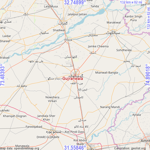
Gujranwala GPS coordinates[2]
32° 9' 20.412" North, 74° 11' 13.38" East
| Map corner | latitude | longitude |
|---|---|---|
| Upper-left | 32.74899°, | 73.48393° |
| Center: | 32.15567°, | 74.18705° |
| Lower-right: | 31.55846°, | 74.89018° |
| Map W x H: | 132.4×132.4 km | = 82.3×82.3mi |
| max Lat: | 36.32162° ⇑32.1% North |
| Gujranwala: | 32.15567° |
| min Lat: | ⇓67.9% South 24.14422° |
| min Long | Gujranwala | max Long |
| 61.74573° | 74.18705° | 75.63372° |
| W 92.6%⇐ | ⇒7.4% E |
Elevation
Elevation of Gujranwala is 230 m = 755 ft, and this is 115 m = 377 ft below average elevation for this country.
| Max E: |
2732 m = 8963 ft | 33% |
| Avg. | 345 m = 1132 ft | |
| Gujranwala | 230 m = 755 ft | |
Min E: |
3 m = 10 ft | 67% |
See also: Gujranwala elevation on elevation.city.
Geographical zone
Gujranwala is located in North temperate zone (between Tropic of Cancer and the Arctic Circle). Distance of this Northern Tropic circle is 969.5 km =602.4 mi to South.| Distance of | km | miles | from Gujranwala |
|---|---|---|---|
| North Pole | 6431.7 | 3996.5 | to North |
| Arctic Circle | 3825.8 | 2377.2 | to North |
| Tropic Cancer | 969.5 | 602.4 | to South |
| Equator | 3575.4 | 2221.6 | to South |


Nearby cities:
15 places around Gujranwala: (largest is in red/bold)
• Begowala
32.3 km =20.1 mi,  13°
13°
• Bhopalwala
34.7 km =21.6 mi,  28°
28°
• Daska Kalan
24.2 km =15 mi,  39°
39°
• Dhaunkal
28.2 km =17.5 mi,  350°
350°
• Eminabad
14.3 km =8.9 mi,  151°
151°
• Kamoke
20.3 km =12.6 mi,  170°
170°
• Kot Ghulam Muhammad
39.2 km =24.4 mi,  59°
59°
• Ladhewala Waraich
6.7 km =4.2 mi,  271°
271°
• Muridke
39.8 km =24.7 mi, 170°
• Narang Mandi
41.8 km =26 mi,  132°
132°
• Naushahra Virkan
29.6 km =18.4 mi,  223°
223°
• Rasulnagar
42.8 km =26.6 mi,  296°
296°
• Sambrial
39.1 km =24.3 mi,  23°
23°
• Sodhri
34.1 km =21.2 mi,  359°
359°
• Wazirabad
32.6 km =20.3 mi, 348°
Sources, notices
• [Note1] Compared only with cities in Pakistan existing in our database
• [Src1] Map data: © OpenStreetMap contributors (CC-BY-SA)
• [Src2] Other city data from geonames.org with taken over terms of usage.
• [Src3] Geographical zone / Annual Mean Temperature by Robert A. Rohde @ Wikipedia
