Kamoke geodata
Kamoke (Punjab) is a populated place; located in Pakistan in Asia/Karachi (GMT+5) time zone. With population of 199,531 people, there are 34 cities with bigger population in this country. Compared to other cities in Pakistan, 65.9% of cities are located further ↓South; 93.2% of cities are located further ←West and 65.5% of cities have lower elevation than Kamoke. Note1


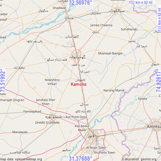
Kamoke GPS coordinates[2]
31° 58' 30.936" North, 74° 13' 22.944" East
| Map corner | latitude | longitude |
|---|---|---|
| Upper-left | 32.56976°, | 73.51992° |
| Center: | 31.97526°, | 74.22304° |
| Lower-right: | 31.37688°, | 74.92617° |
| Map W x H: | 132.6×132.6 km | = 82.4×82.4mi |
| max Lat: | 36.32162° ⇑34.1% North |
| Kamoke: | 31.97526° |
| min Lat: | ⇓65.9% South 24.14422° |
| min Long | Kamoke | max Long |
| 61.74573° | 74.22304° | 75.63372° |
| W 93.2%⇐ | ⇒6.8% E |
Elevation
Elevation of Kamoke is 221 m = 725 ft, and this is 124 m = 407 ft below average elevation for this country.
| Max E: |
2732 m = 8963 ft | 34.5% |
| Avg. | 345 m = 1132 ft | |
| Kamoke | 221 m = 725 ft | |
Min E: |
3 m = 10 ft | 65.5% |
See also: Kamoke elevation on elevation.city.
Geographical zone
Kamoke is located in North temperate zone (between Tropic of Cancer and the Arctic Circle). Distance of this Northern Tropic circle is 949.4 km =589.9 mi to South.| Distance of | km | miles | from Kamoke |
|---|---|---|---|
| North Pole | 6451.7 | 4008.9 | to North |
| Arctic Circle | 3845.9 | 2389.7 | to North |
| Tropic Cancer | 949.4 | 589.9 | to South |
| Equator | 3555.3 | 2209.2 | to South |


Nearby cities:
15 places around Kamoke: (largest is in red/bold)
• Baddomalhi
41.6 km =25.8 mi,  87°
87°
• Chuchar-kana Mandi
47.2 km =29.3 mi,  237°
237°
• Daska Kalan
40.6 km =25.2 mi,  17°
17°
• Dhaunkal
48.6 km =30.2 mi,  350°
350°
• Eminabad
8.2 km =5.1 mi,  25°
25°
• Gujranwala
20.3 km =12.6 mi, 350°
• Jandiala Sher Khan
33.5 km =20.8 mi, 239°
• Kalaswala
47.3 km =29.4 mi,  57°
57°
• Kot Ghulam Muhammad
50.1 km =31.1 mi,  37°
37°
• Ladhewala Waraich
22.6 km =14 mi,  333°
333°
• Lahore
47.9 km =29.8 mi,  165°
165°
• Muridke
19.5 km =12.1 mi, 170°
• Narang Mandi
28.8 km =17.9 mi,  106°
106°
• Naushahra Virkan
23.8 km =14.8 mi,  266°
266°
• Shekhupura
36.8 km =22.9 mi,  217°
217°
Sources, notices
• [Note1] Compared only with cities in Pakistan existing in our database
• [Src1] Map data: © OpenStreetMap contributors (CC-BY-SA)
• [Src2] Other city data from geonames.org with taken over terms of usage.
• [Src3] Geographical zone / Annual Mean Temperature by Robert A. Rohde @ Wikipedia
