Muridke geodata
Muridke (Punjab) is a populated place; located in Pakistan in Asia/Karachi (GMT+5) time zone. With population of 164,246 people, there are 39 cities with bigger population in this country. Compared to other cities in Pakistan, 62.1% of cities are located further ↓South; 93.7% of cities are located further ←West and 63.9% of cities have lower elevation than Muridke. Note1


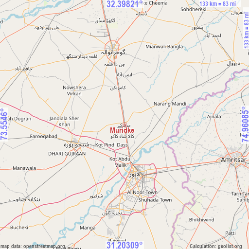
Muridke GPS coordinates[2]
31° 48' 9.288" North, 74° 15' 27.792" East
| Map corner | latitude | longitude |
|---|---|---|
| Upper-left | 32.39821°, | 73.5546° |
| Center: | 31.80258°, | 74.25772° |
| Lower-right: | 31.20309°, | 74.96085° |
| Map W x H: | 132.9×132.9 km | = 82.6×82.6mi |
| max Lat: | 36.32162° ⇑37.9% North |
| Muridke: | 31.80258° |
| min Lat: | ⇓62.1% South 24.14422° |
| min Long | Muridke | max Long |
| 61.74573° | 74.25772° | 75.63372° |
| W 93.7%⇐ | ⇒6.3% E |
Elevation
Elevation of Muridke is 216 m = 709 ft, and this is 129 m = 423 ft below average elevation for this country.
| Max E: |
2732 m = 8963 ft | 36.1% |
| Avg. | 345 m = 1132 ft | |
| Muridke | 216 m = 709 ft | |
Min E: |
3 m = 10 ft | 63.9% |
See also: Muridke elevation on elevation.city.
Geographical zone
Muridke is located in North temperate zone (between Tropic of Cancer and the Arctic Circle). Distance of this Northern Tropic circle is 930.2 km =578 mi to South.| Distance of | km | miles | from Muridke |
|---|---|---|---|
| North Pole | 6470.9 | 4020.8 | to North |
| Arctic Circle | 3865.1 | 2401.7 | to North |
| Tropic Cancer | 930.2 | 578 | to South |
| Equator | 3536.1 | 2197.2 | to South |


Nearby cities:
15 places around Muridke: (largest is in red/bold)
• Baddomalhi
43.7 km =27.2 mi,  61°
61°
• Chak Five Hundred Seventy-five
49.7 km =30.9 mi,  234°
234°
• Chuchar-kana Mandi
43.7 km =27.2 mi,  262°
262°
• Eminabad
26.7 km =16.6 mi,  0°
0°
• Gujranwala
39.8 km =24.7 mi,  350°
350°
• Jandiala Sher Khan
32.2 km =20 mi,  273°
273°
• Kahna Nau
49.6 km =30.8 mi,  167°
167°
• Kalaswala
57.6 km =35.8 mi,  39°
39°
• Kamoke
19.5 km =12.1 mi, 350°
• Ladhewala Waraich
41.6 km =25.8 mi,  341°
341°
• Lahore
28.6 km =17.8 mi,  162°
162°
• Narang Mandi
26.9 km =16.7 mi,  65°
65°
• Naushahra Virkan
32.4 km =20.1 mi,  303°
303°
• Sharqpur Sharif
40.8 km =25.4 mi,  201°
201°
• Shekhupura
27.6 km =17.1 mi,  248°
248°
Sources, notices
• [Note1] Compared only with cities in Pakistan existing in our database
• [Src1] Map data: © OpenStreetMap contributors (CC-BY-SA)
• [Src2] Other city data from geonames.org with taken over terms of usage.
• [Src3] Geographical zone / Annual Mean Temperature by Robert A. Rohde @ Wikipedia
