Khangah Dogran geodata
Khangah Dogran (Punjab) is a populated place; located in Pakistan in Asia/Karachi (GMT+5) time zone. With population of 30,314 people, there are 206 cities with bigger population in this country. Compared to other cities in Pakistan, 63.4% of cities are located further ↓South; 83.3% of cities are located further ←West and 60.5% of cities have lower elevation than Khangah Dogran. Note1


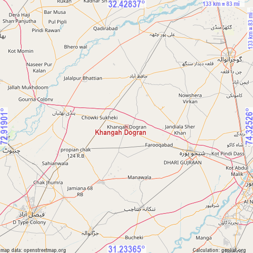
Khangah Dogran GPS coordinates[2]
31° 49' 58.584" North, 73° 37' 19.668" East
| Map corner | latitude | longitude |
|---|---|---|
| Upper-left | 32.42837°, | 72.91901° |
| Center: | 31.83294°, | 73.62213° |
| Lower-right: | 31.23365°, | 74.32526° |
| Map W x H: | 132.8×132.8 km | = 82.5×82.5mi |
| max Lat: | 36.32162° ⇑36.6% North |
| Khangah Dogran: | 31.83294° |
| min Lat: | ⇓63.4% South 24.14422° |
| min Long | Khangah Dogran | max Long |
| 61.74573° | 73.62213° | 75.63372° |
| W 83.3%⇐ | ⇒16.7% E |
Elevation
Elevation of Khangah Dogran is 207 m = 679 ft, and this is 138 m = 453 ft below average elevation for this country.
| Max E: |
2732 m = 8963 ft | 39.5% |
| Avg. | 345 m = 1132 ft | |
| Khangah Dogran | 207 m = 679 ft | |
Min E: |
3 m = 10 ft | 60.5% |
See also: Pakistan elevation on elevation.city.
Geographical zone
Khangah Dogran is located in North temperate zone (between Tropic of Cancer and the Arctic Circle). Distance of this Northern Tropic circle is 933.6 km =580.1 mi to South.| Distance of | km | miles | from Khangah Dogran |
|---|---|---|---|
| North Pole | 6467.6 | 4018.8 | to North |
| Arctic Circle | 3861.7 | 2399.5 | to North |
| Tropic Cancer | 933.6 | 580.1 | to South |
| Equator | 3539.5 | 2199.3 | to South |


Nearby cities:
15 places around Khangah Dogran: (largest is in red/bold)
• Chak Five Hundred Seventy-five
37.5 km =23.3 mi,  148°
148°
• Chak Jhumra
50.9 km =31.6 mi,  234°
234°
• Chuchar-kana Mandi
19.2 km =11.9 mi,  118°
118°
• Hafizabad
27.2 km =16.9 mi,  13°
13°
• Jandiala Sher Khan
28 km =17.4 mi,  92°
92°
• Kaleke Mandi
16 km =9.9 mi,  352°
352°
• Khurrianwala
50 km =31.1 mi,  222°
222°
• Mananwala
28 km =17.4 mi,  166°
166°
• Nankana Sahib
43.3 km =26.9 mi, 169°
• Naushahra Virkan
36 km =22.4 mi,  66°
66°
• Pindi Bhattian
33.7 km =20.9 mi,  282°
282°
• Sangla Hill
26 km =16.2 mi,  240°
240°
• Shahkot
31.9 km =19.8 mi,  203°
203°
• Shekhupura
36.9 km =22.9 mi,  111°
111°
• Sukheke Mandi
11.3 km =7 mi,  288°
288°
Sources, notices
• [Note1] Compared only with cities in Pakistan existing in our database
• [Src1] Map data: © OpenStreetMap contributors (CC-BY-SA)
• [Src2] Other city data from geonames.org with taken over terms of usage.
• [Src3] Geographical zone / Annual Mean Temperature by Robert A. Rohde @ Wikipedia
