Shahkot geodata
Shahkot (Punjab) is a populated place; located in Pakistan in Asia/Karachi (GMT+5) time zone. With population of 200,000 people, there are 33 cities with bigger population in this country. Compared to other cities in Pakistan, 60% of cities are located further ↓South; 81.3% of cities are located further ←West and 57.6% of cities have lower elevation than Shahkot. Note1


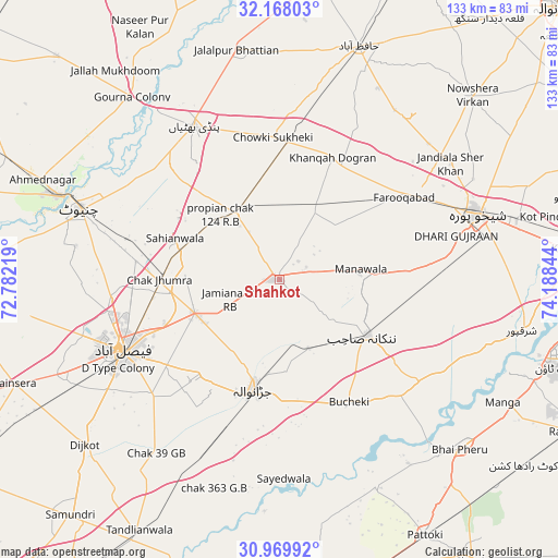
Shahkot GPS coordinates[2]
31° 34' 15.24" North, 73° 29' 7.116" East
| Map corner | latitude | longitude |
|---|---|---|
| Upper-left | 32.16803°, | 72.78219° |
| Center: | 31.5709°, | 73.48531° |
| Lower-right: | 30.96992°, | 74.18844° |
| Map W x H: | 133.2×133.2 km | = 82.8×82.8mi |
| max Lat: | 36.32162° ⇑40% North |
| Shahkot: | 31.5709° |
| min Lat: | ⇓60% South 24.14422° |
| min Long | Shahkot | max Long |
| 61.74573° | 73.48531° | 75.63372° |
| W 81.3%⇐ | ⇒18.7% E |
Elevation
Elevation of Shahkot is 197 m = 646 ft, and this is 148 m = 486 ft below average elevation for this country.
| Max E: |
2732 m = 8963 ft | 42.4% |
| Avg. | 345 m = 1132 ft | |
| Shahkot | 197 m = 646 ft | |
Min E: |
3 m = 10 ft | 57.6% |
See also: Shahkot elevation on elevation.city.
Geographical zone
Shahkot is located in North temperate zone (between Tropic of Cancer and the Arctic Circle). Distance of this Northern Tropic circle is 904.4 km =562 mi to South.| Distance of | km | miles | from Shahkot |
|---|---|---|---|
| North Pole | 6496.7 | 4036.9 | to North |
| Arctic Circle | 3890.8 | 2417.6 | to North |
| Tropic Cancer | 904.4 | 562 | to South |
| Equator | 3510.4 | 2181.3 | to South |


Nearby cities:
15 places around Shahkot: (largest is in red/bold)
• Chak Five Hundred Seventy-five
32.7 km =20.3 mi,  95°
95°
• Chak Jhumra
28.6 km =17.8 mi,  269°
269°
• Chuchar-kana Mandi
35.8 km =22.2 mi,  56°
56°
• Faisalabad
41.3 km =25.7 mi,  245°
245°
• Jandiala Sher Khan
49.5 km =30.8 mi, 55°
• Jaranwala
27.2 km =16.9 mi,  193°
193°
• Kaleke Mandi
46.3 km =28.8 mi,  13°
13°
• Khangah Dogran
31.9 km =19.8 mi,  23°
23°
• Khurrianwala
22.1 km =13.7 mi, 248°
• Mananwala
19.4 km =12.1 mi,  84°
84°
• Nankana Sahib
24.9 km =15.5 mi,  122°
122°
• Pindi Bhattian
41.6 km =25.8 mi,  331°
331°
• Sangla Hill
18.9 km =11.7 mi, 329°
• Shekhupura
49.9 km =31 mi,  71°
71°
• Sukheke Mandi
32.8 km =20.4 mi,  3°
3°
Sources, notices
• [Note1] Compared only with cities in Pakistan existing in our database
• [Src1] Map data: © OpenStreetMap contributors (CC-BY-SA)
• [Src2] Other city data from geonames.org with taken over terms of usage.
• [Src3] Geographical zone / Annual Mean Temperature by Robert A. Rohde @ Wikipedia
