Khurrianwala geodata
Khurrianwala (Punjab) is a populated place; located in Pakistan in Asia/Karachi (GMT+5) time zone. With population of 35,292 people, there are 177 cities with bigger population in this country. Compared to other cities in Pakistan, 58.9% of cities are located further ↓South; 78.3% of cities are located further ←West and 54.6% of cities have lower elevation than Khurrianwala. Note1


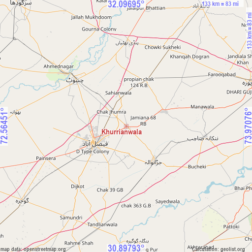
Khurrianwala GPS coordinates[2]
31° 29' 57.696" North, 73° 16' 3.468" East
| Map corner | latitude | longitude |
|---|---|---|
| Upper-left | 32.09695°, | 72.56451° |
| Center: | 31.49936°, | 73.26763° |
| Lower-right: | 30.89793°, | 73.97076° |
| Map W x H: | 133.3×133.3 km | = 82.8×82.8mi |
| max Lat: | 36.32162° ⇑41.1% North |
| Khurrianwala: | 31.49936° |
| min Lat: | ⇓58.9% South 24.14422° |
| min Long | Khurrianwala | max Long |
| 61.74573° | 73.26763° | 75.63372° |
| W 78.3%⇐ | ⇒21.7% E |
Elevation
Elevation of Khurrianwala is 190 m = 623 ft, and this is 155 m = 509 ft below average elevation for this country.
| Max E: |
2732 m = 8963 ft | 45.4% |
| Avg. | 345 m = 1132 ft | |
| Khurrianwala | 190 m = 623 ft | |
Min E: |
3 m = 10 ft | 54.6% |
See also: Pakistan elevation on elevation.city.
Geographical zone
Khurrianwala is located in North temperate zone (between Tropic of Cancer and the Arctic Circle). Distance of this Northern Tropic circle is 896.5 km =557.1 mi to South.| Distance of | km | miles | from Khurrianwala |
|---|---|---|---|
| North Pole | 6504.7 | 4041.8 | to North |
| Arctic Circle | 3898.8 | 2422.6 | to North |
| Tropic Cancer | 896.5 | 557.1 | to South |
| Equator | 3502.4 | 2176.3 | to South |


Nearby cities:
15 places around Khurrianwala: (largest is in red/bold)
• Chak Five Hundred Seventy-five
53.4 km =33.2 mi,  84°
84°
• Chak Jhumra
11.1 km =6.9 mi,  313°
313°
• Chenab Nagar
43.9 km =27.3 mi, 310°
• Chiniot
36.8 km =22.9 mi, 311°
• Dijkot
40.6 km =25.2 mi,  219°
219°
• Faisalabad
19.3 km =12 mi,  241°
241°
• Jaranwala
23.4 km =14.5 mi,  142°
142°
• Khangah Dogran
50 km =31.1 mi,  42°
42°
• Mananwala
41.2 km =25.6 mi, 76°
• Nankana Sahib
42 km =26.1 mi,  97°
97°
• Pindi Bhattian
44.4 km =27.6 mi,  0°
0°
• Sangla Hill
26.5 km =16.5 mi,  24°
24°
• Shahkot
22.1 km =13.7 mi,  68°
68°
• Sukheke Mandi
46.7 km =29 mi,  29°
29°
• Tandlianwala
53.4 km =33.2 mi,  193°
193°
Sources, notices
• [Note1] Compared only with cities in Pakistan existing in our database
• [Src1] Map data: © OpenStreetMap contributors (CC-BY-SA)
• [Src2] Other city data from geonames.org with taken over terms of usage.
• [Src3] Geographical zone / Annual Mean Temperature by Robert A. Rohde @ Wikipedia
