Nankana Sahib geodata
Nankana Sahib (Punjab) is a populated place; located in Pakistan in Asia/Karachi (GMT+5) time zone. With population of 56,366 people, there are 122 cities with bigger population in this country. Compared to other cities in Pakistan, 58.5% of cities are located further ↓South; 84.4% of cities are located further ←West and 58.2% of cities have lower elevation than Nankana Sahib. Note1


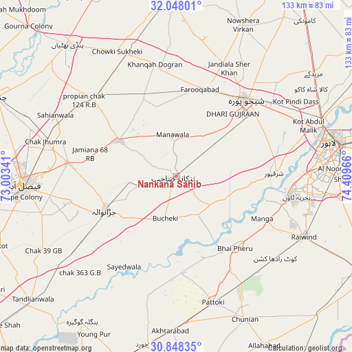
Nankana Sahib GPS coordinates[2]
31° 27' 0.36" North, 73° 42' 23.508" East
| Map corner | latitude | longitude |
|---|---|---|
| Upper-left | 32.04801°, | 73.00341° |
| Center: | 31.4501°, | 73.70653° |
| Lower-right: | 30.84835°, | 74.40966° |
| Map W x H: | 133.4×133.4 km | = 82.9×82.9mi |
| max Lat: | 36.32162° ⇑41.5% North |
| Nankana Sahib: | 31.4501° |
| min Lat: | ⇓58.5% South 24.14422° |
| min Long | Nankana Sahib | max Long |
| 61.74573° | 73.70653° | 75.63372° |
| W 84.4%⇐ | ⇒15.6% E |
Elevation
Elevation of Nankana Sahib is 198 m = 650 ft, and this is 147 m = 482 ft below average elevation for this country.
| Max E: |
2732 m = 8963 ft | 41.8% |
| Avg. | 345 m = 1132 ft | |
| Nankana Sahib | 198 m = 650 ft | |
Min E: |
3 m = 10 ft | 58.2% |
See also: Nankana Sahib elevation on elevation.city.
Geographical zone
Nankana Sahib is located in North temperate zone (between Tropic of Cancer and the Arctic Circle). Distance of this Northern Tropic circle is 891 km =553.6 mi to South.| Distance of | km | miles | from Nankana Sahib |
|---|---|---|---|
| North Pole | 6510.1 | 4045.2 | to North |
| Arctic Circle | 3904.3 | 2426 | to North |
| Tropic Cancer | 891 | 553.6 | to South |
| Equator | 3496.9 | 2172.9 | to South |


Nearby cities:
15 places around Nankana Sahib: (largest is in red/bold)
• Chak Five Hundred Seventy-five
15.7 km =9.8 mi,  47°
47°
• Chuchar-kana Mandi
34.5 km =21.4 mi,  14°
14°
• Jandiala Sher Khan
45.8 km =28.5 mi,  25°
25°
• Jaranwala
30.3 km =18.8 mi,  244°
244°
• Khangah Dogran
43.3 km =26.9 mi,  349°
349°
• Khurrianwala
42 km =26.1 mi,  277°
277°
• Kot Radha Kishan
48.7 km =30.3 mi,  129°
129°
• Mananwala
15.4 km =9.6 mi, 353°
• Mianke Mor
35.9 km =22.3 mi,  140°
140°
• Pattoki
49.8 km =30.9 mi,  163°
163°
• Sangla Hill
42.6 km =26.5 mi,  314°
314°
• Shahkot
24.9 km =15.5 mi,  302°
302°
• Sharqpur Sharif
37.4 km =23.2 mi,  88°
88°
• Shekhupura
39.4 km =24.5 mi,  42°
42°
• Sukheke Mandi
49.8 km =30.9 mi,  337°
337°
Sources, notices
• [Note1] Compared only with cities in Pakistan existing in our database
• [Src1] Map data: © OpenStreetMap contributors (CC-BY-SA)
• [Src2] Other city data from geonames.org with taken over terms of usage.
• [Src3] Geographical zone / Annual Mean Temperature by Robert A. Rohde @ Wikipedia
