Mehar geodata
Mehar (Sindh) is a populated place; located in Pakistan in Asia/Karachi (GMT+5) time zone. With population of 30,429 people, there are 205 cities with bigger population in this country. Compared to other cities in Pakistan, 80.8% of cities are located further ↑North; 91% of cities are located further →East and 84% of cities have higher elevation than Mehar. Note1


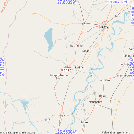
Mehar GPS coordinates[2]
27° 10' 48.972" North, 67° 49' 13.836" East
| Map corner | latitude | longitude |
|---|---|---|
| Upper-left | 27.80399°, | 67.11739° |
| Center: | 27.18027°, | 67.82051° |
| Lower-right: | 26.55304°, | 68.52364° |
| Map W x H: | 139.1×139.1 km | = 86.4×86.4mi |
| max Lat: | 36.32162° ⇑80.8% North |
| Mehar: | 27.18027° |
| min Lat: | ⇓19.2% South 24.14422° |
| min Long | Mehar | max Long |
| 61.74573° | 67.82051° | 75.63372° |
| W 9%⇐ | ⇒91% E |
Elevation
Elevation of Mehar is 48 m = 157 ft, and this is 297 m = 974 ft below average elevation for this country.
| Max E: |
2732 m = 8963 ft | 84% |
| Avg. | 345 m = 1132 ft | |
| Mehar | 48 m = 157 ft | |
Min E: |
3 m = 10 ft | 16% |
See also: Pakistan elevation on elevation.city.
Geographical zone
Mehar is located in North temperate zone (between Tropic of Cancer and the Arctic Circle). Distance of this Northern Tropic circle is 416.2 km =258.6 mi to South.| Distance of | km | miles | from Mehar |
|---|---|---|---|
| North Pole | 6984.9 | 4340.2 | to North |
| Arctic Circle | 4379 | 2721 | to North |
| Tropic Cancer | 416.2 | 258.6 | to South |
| Equator | 3022.2 | 1877.9 | to South |


Nearby cities:
15 places around Mehar: (largest is in red/bold)
• Bhiria
47.7 km =29.6 mi,  129°
129°
• Dadu
50.2 km =31.2 mi,  184°
184°
• Dokri
34.8 km =21.6 mi,  51°
51°
• Goth Garelo
37.9 km =23.5 mi,  41°
41°
• Goth Phulji
36 km =22.4 mi,  202°
202°
• Goth Radhan
13.3 km =8.3 mi,  81°
81°
• Kambar
48.7 km =30.3 mi,  21°
21°
• Kandiaro
40.9 km =25.4 mi,  109°
109°
• Khairpur Nathan Shah
13.1 km =8.1 mi,  220°
220°
• Nasirabad
24.3 km =15.1 mi, 22°
• Naushahro Firoz
48.2 km =30 mi,  141°
141°
• New Bādāh
27.5 km =17.1 mi, 49°
• Sīta Road
16.6 km =10.3 mi,  169°
169°
• Tharu Shah
39.6 km =24.6 mi, 131°
• Warah
29.9 km =18.6 mi,  355°
355°
Sources, notices
• [Note1] Compared only with cities in Pakistan existing in our database
• [Src1] Map data: © OpenStreetMap contributors (CC-BY-SA)
• [Src2] Other city data from geonames.org with taken over terms of usage.
• [Src3] Geographical zone / Annual Mean Temperature by Robert A. Rohde @ Wikipedia
