Attock City geodata
Attock City (Punjab) is a seat of a second-order administrative division; located in Pakistan in Asia/Karachi (GMT+5) time zone. With population of 85,479 people, there are 78 cities with bigger population in this country. Compared to other cities in Pakistan, 87.4% of cities are located further ↓South; 62.3% of cities are located further ←West and 79% of cities have lower elevation than Attock City. Note1


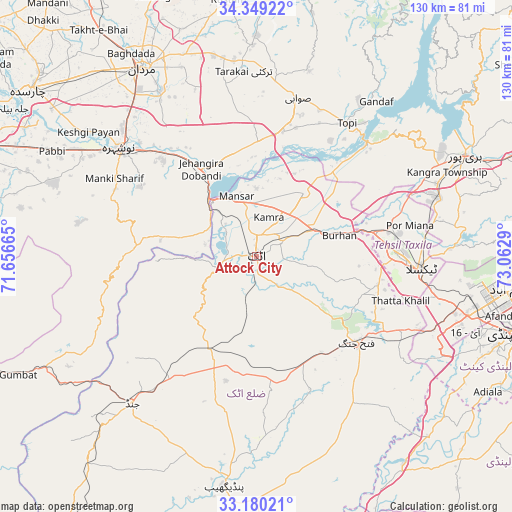
Attock City GPS coordinates[2]
33° 46' 0.156" North, 72° 21' 35.172" East
| Map corner | latitude | longitude |
|---|---|---|
| Upper-left | 34.34922°, | 71.65665° |
| Center: | 33.76671°, | 72.35977° |
| Lower-right: | 33.18021°, | 73.0629° |
| Map W x H: | 130×130 km | = 80.8×80.8mi |
| max Lat: | 36.32162° ⇑12.6% North |
| Attock City: | 33.76671° |
| min Lat: | ⇓87.4% South 24.14422° |
| min Long | Attock City | max Long |
| 61.74573° | 72.35977° | 75.63372° |
| W 62.3%⇐ | ⇒37.7% E |
Elevation
Elevation of Attock City is 355 m = 1165 ft, and this is 10 m = 33 ft above average elevation for this country.
| Max E: |
2732 m = 8963 ft | 21% |
| Attock City | 355 m 1165 ft | |
| Avg. | 345 m = 1132 ft | |
Min E: |
3 m = 10 ft | 79% |
See also: Attock City elevation on elevation.city.
Geographical zone
Attock City is located in North temperate zone (between Tropic of Cancer and the Arctic Circle). Distance of this Northern Tropic circle is 1148.6 km =713.7 mi to South.| Distance of | km | miles | from Attock City |
|---|---|---|---|
| North Pole | 6252.6 | 3885.2 | to North |
| Arctic Circle | 3646.7 | 2266 | to North |
| Tropic Cancer | 1148.6 | 713.7 | to South |
| Equator | 3754.5 | 2332.9 | to South |


Nearby cities:
15 places around Attock City: (largest is in red/bold)
• Akora
34.1 km =21.2 mi,  320°
320°
• Aman Garh
47.8 km =29.7 mi,  303°
303°
• Ashanagro Koto
39.4 km =24.5 mi,  344°
344°
• Cherat Cantonement
43.6 km =27.1 mi,  278°
278°
• Hazro City
20.1 km =12.5 mi,  37°
37°
• Jand
48.7 km =30.3 mi,  220°
220°
• Khalabat
58.8 km =36.5 mi,  56°
56°
• Mardan
55.8 km =34.7 mi,  329°
329°
• Nowshera
44.6 km =27.7 mi,  308°
308°
• Nowshera Cantonment
42.1 km =26.2 mi, 307°
• Risalpur Cantonment
47.1 km =29.3 mi, 313°
• Sanjwal
6.8 km =4.2 mi,  95°
95°
• Swabi
40.6 km =25.2 mi,  14°
14°
• Topi
41.5 km =25.8 mi, 35°
• Zaida
34 km =21.1 mi,  16°
16°
Sources, notices
• [Note1] Compared only with cities in Pakistan existing in our database
• [Src1] Map data: © OpenStreetMap contributors (CC-BY-SA)
• [Src2] Other city data from geonames.org with taken over terms of usage.
• [Src3] Geographical zone / Annual Mean Temperature by Robert A. Rohde @ Wikipedia
