Kaczeniec geodata
Kaczeniec (Lubusz) is a populated place; located in Poland in Europe/Warsaw (GMT+2) time zone. With population of 600 people, there are 3270 cities with bigger population in this country. Compared to other cities in Poland, 62.5% of cities are located further ↓South; 96.3% of cities are located further →East and 89.2% of cities have higher elevation than Kaczeniec. Note1
Administrative division(s):
- Level 1: Lubusz
- Level 2: Powiat zielonogórski
- Level 3: Nowogród Bobrzański


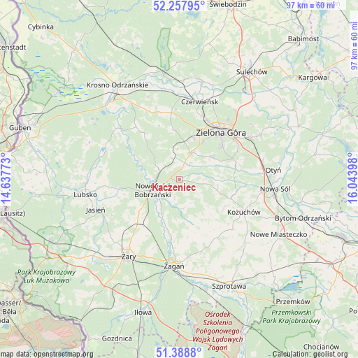
Kaczeniec GPS coordinates[2]
51° 49' 31.692" North, 15° 20' 27.06" East
| Map corner | latitude | longitude |
|---|---|---|
| Upper-left | 52.25795°, | 14.63773° |
| Center: | 51.82547°, | 15.34085° |
| Lower-right: | 51.3888°, | 16.04398° |
| Map W x H: | 96.6×96.6 km | = 60×60mi |
| max Lat: | 54.83135° ⇑37.5% North |
| Kaczeniec: | 51.82547° |
| min Lat: | ⇓62.5% South 49.21328° |
| min Long | Kaczeniec | max Long |
| 14.20249° | 15.34085° | 24.03723° |
| W 3.7%⇐ | ⇒96.3% E |
Elevation
Elevation of Kaczeniec is 78 m = 256 ft, and this is 113.4 m = 372 ft below average elevation for this country.
| Max E: |
974 m = 3196 ft | 89.2% |
| Avg. | 191.4 m = 628 ft | |
| Kaczeniec | 78 m = 256 ft | |
Min E: |
-3 m = -10 ft | 10.8% |
See also: Poland elevation on elevation.city.
Geographical zone
Kaczeniec is located in North temperate zone (between Tropic of Cancer and the Arctic Circle). Distance of this North polar circle is 1638.7 km =1018.2 mi to North.| Distance of | km | miles | from Kaczeniec |
|---|---|---|---|
| North Pole | 4244.6 | 2637.5 | to North |
| Arctic Circle | 1638.7 | 1018.2 | to North |
| Tropic Cancer | 3156.5 | 1961.4 | to South |
| Equator | 5762.5 | 3580.7 | to South |


Nearby cities:
15 places around Kaczeniec: (largest is in red/bold)
• Bobrowice
22 km =13.7 mi,  308°
308°
• Brzeźnica
12.9 km =8 mi,  163°
163°
• Czerwieńsk
21.6 km =13.4 mi,  15°
15°
• Dąbie
24.3 km =15.1 mi,  327°
327°
• Jasień
23.9 km =14.9 mi,  249°
249°
• Kożuchów
19.6 km =12.2 mi,  116°
116°
• Niwiska
3.5 km =2.2 mi,  99°
99°
• Nowogród Bobrzański
7.9 km =4.9 mi, 247°
• Ochla
10.8 km =6.7 mi,  56°
56°
• Otyń
25.6 km =15.9 mi,  84°
84°
• Ploty
18.5 km =11.5 mi, 15°
• Zielona Góra
16.7 km =10.4 mi,  42°
42°
• Świdnica
7.8 km =4.8 mi,  25°
25°
• Żagań
23.2 km =14.4 mi,  184°
184°
• Żary
24.7 km =15.3 mi,  214°
214°
Sources, notices
• [Note1] Compared only with cities in Poland existing in our database
• [Src1] Map data: © OpenStreetMap contributors (CC-BY-SA)
• [Src2] Other city data from geonames.org with taken over terms of usage.
• [Src3] Geographical zone / Annual Mean Temperature by Robert A. Rohde @ Wikipedia
