Bobrowniki geodata
Bobrowniki (Lubusz) is a populated place; located in Poland in Europe/Warsaw (GMT+2) time zone. With population of 650 people, there are 3162 cities with bigger population in this country. Compared to other cities in Poland, 63% of cities are located further ↓South; 94.1% of cities are located further →East and 85.7% of cities have higher elevation than Bobrowniki. Note1


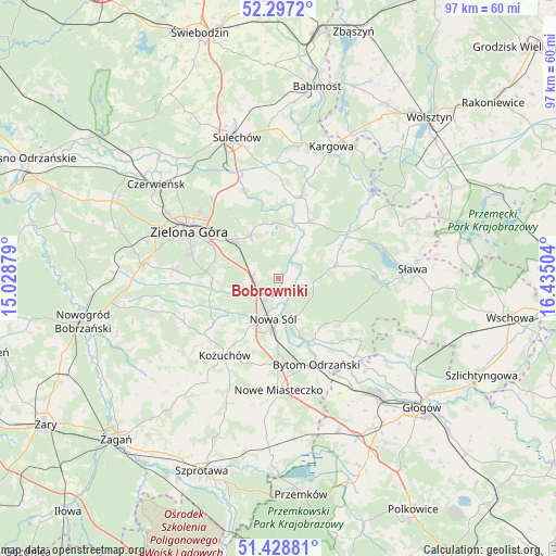
Bobrowniki GPS coordinates[2]
51° 51' 54.36" North, 15° 43' 54.876" East
| Map corner | latitude | longitude |
|---|---|---|
| Upper-left | 52.2972°, | 15.02879° |
| Center: | 51.8651°, | 15.73191° |
| Lower-right: | 51.42881°, | 16.43504° |
| Map W x H: | 96.6×96.6 km | = 60×60mi |
| max Lat: | 54.83135° ⇑37% North |
| Bobrowniki: | 51.8651° |
| min Lat: | ⇓63% South 49.21328° |
| min Long | Bobrowniki | max Long |
| 14.20249° | 15.73191° | 24.03723° |
| W 5.9%⇐ | ⇒94.1% E |
Elevation
Elevation of Bobrowniki is 88 m = 289 ft, and this is 103.4 m = 339 ft below average elevation for this country.
| Max E: |
974 m = 3196 ft | 85.7% |
| Avg. | 191.4 m = 628 ft | |
| Bobrowniki | 88 m = 289 ft | |
Min E: |
-3 m = -10 ft | 14.3% |
See also: Poland elevation on elevation.city.
Geographical zone
Bobrowniki is located in North temperate zone (between Tropic of Cancer and the Arctic Circle). Distance of this North polar circle is 1634.3 km =1015.5 mi to North.| Distance of | km | miles | from Bobrowniki |
|---|---|---|---|
| North Pole | 4240.2 | 2634.7 | to North |
| Arctic Circle | 1634.3 | 1015.5 | to North |
| Tropic Cancer | 3160.9 | 1964.1 | to South |
| Equator | 5766.9 | 3583.4 | to South |


Nearby cities:
15 places around Bobrowniki: (largest is in red/bold)
• Bielawy
17.7 km =11 mi,  126°
126°
• Bojadła
11.2 km =7 mi,  28°
28°
• Bytom Odrzański
16.2 km =10.1 mi,  157°
157°
• Klenica
14.6 km =9.1 mi,  14°
14°
• Konotop
13.9 km =8.6 mi,  57°
57°
• Kożuchów
16.3 km =10.1 mi,  215°
215°
• Lubięcin
10.3 km =6.4 mi,  74°
74°
• Nowa Sól
6.9 km =4.3 mi,  188°
188°
• Otyń
2.4 km =1.5 mi, 216°
• Przyborów
7.7 km =4.8 mi, 160°
• Siedlisko
12.1 km =7.5 mi,  152°
152°
• Swarzynice
15.2 km =9.4 mi, 5°
• Trzebiechów
17.4 km =10.8 mi,  0°
0°
• Zabór
9.7 km =6 mi,  353°
353°
• Zielona Góra
17.3 km =10.7 mi,  296°
296°
Sources, notices
• [Note1] Compared only with cities in Poland existing in our database
• [Src1] Map data: © OpenStreetMap contributors (CC-BY-SA)
• [Src2] Other city data from geonames.org with taken over terms of usage.
• [Src3] Geographical zone / Annual Mean Temperature by Robert A. Rohde @ Wikipedia
