Szczerców geodata
Szczerców (Łódź Voivodeship) is a seat of a third-order administrative division; located in Poland in Europe/Warsaw (GMT+2) time zone. With population of 3,300 people, there are 966 cities with bigger population in this country. Compared to other cities in Poland, 53.7% of cities are located further ↓South; 58.1% of cities are located further →East and 51.9% of cities have higher elevation than Szczerców. Note1
Administrative division(s):
- Level 1: Łódź Voivodeship
- Level 2: Powiat bełchatowski
- Level 3: Szczerców


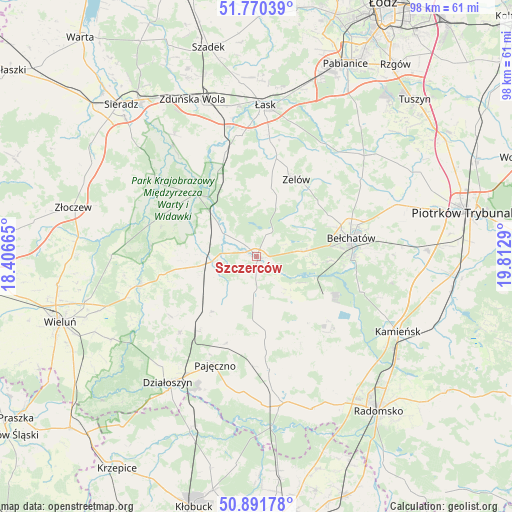
Szczerców GPS coordinates[2]
51° 19' 59.484" North, 19° 6' 35.172" East
| Map corner | latitude | longitude |
|---|---|---|
| Upper-left | 51.77039°, | 18.40665° |
| Center: | 51.33319°, | 19.10977° |
| Lower-right: | 50.89178°, | 19.8129° |
| Map W x H: | 97.7×97.7 km | = 60.7×60.7mi |
| max Lat: | 54.83135° ⇑46.3% North |
| Szczerców: | 51.33319° |
| min Lat: | ⇓53.7% South 49.21328° |
| min Long | Szczerców | max Long |
| 14.20249° | 19.10977° | 24.03723° |
| W 41.9%⇐ | ⇒58.1% E |
Elevation
Elevation of Szczerców is 167 m = 548 ft, and this is 24.4 m = 80 ft below average elevation for this country.
| Max E: |
974 m = 3196 ft | 51.9% |
| Avg. | 191.4 m = 628 ft | |
| Szczerców | 167 m = 548 ft | |
Min E: |
-3 m = -10 ft | 48.1% |
See also: Poland elevation on elevation.city.
Geographical zone
Szczerców is located in North temperate zone (between Tropic of Cancer and the Arctic Circle). Distance of this North polar circle is 1693.5 km =1052.3 mi to North.| Distance of | km | miles | from Szczerców |
|---|---|---|---|
| North Pole | 4299.3 | 2671.5 | to North |
| Arctic Circle | 1693.5 | 1052.3 | to North |
| Tropic Cancer | 3101.8 | 1927.4 | to South |
| Equator | 5707.7 | 3546.6 | to South |


Nearby cities:
15 places around Szczerców: (largest is in red/bold)
• Bełchatów
17.6 km =10.9 mi,  76°
76°
• Buczek
19.2 km =11.9 mi,  11°
11°
• Kiełczygłów
13.7 km =8.5 mi,  220°
220°
• Kleszczów
18.2 km =11.3 mi,  132°
132°
• Kluki
9.1 km =5.7 mi, 83°
• Konopnica
20 km =12.4 mi,  276°
276°
• Lipnik
20.1 km =12.5 mi,  236°
236°
• Rusiec
8.7 km =5.4 mi,  263°
263°
• Rząśnia
13.3 km =8.3 mi,  200°
200°
• Siemkowice
20.7 km =12.9 mi,  225°
225°
• Sulmierzyce
17.6 km =10.9 mi,  160°
160°
• Sędziejowice
20.1 km =12.5 mi,  343°
343°
• Widawa
16.4 km =10.2 mi,  315°
315°
• Zelów
16.5 km =10.3 mi,  27°
27°
• Łękińsko
20.9 km =13 mi, 127°
Sources, notices
• [Note1] Compared only with cities in Poland existing in our database
• [Src1] Map data: © OpenStreetMap contributors (CC-BY-SA)
• [Src2] Other city data from geonames.org with taken over terms of usage.
• [Src3] Geographical zone / Annual Mean Temperature by Robert A. Rohde @ Wikipedia
