Sędziejowice geodata
Sędziejowice (Łódź Voivodeship) is a seat of a third-order administrative division; located in Poland in Europe/Warsaw (GMT+2) time zone. With population of 840 people, there are 2782 cities with bigger population in this country. Compared to other cities in Poland, 56.5% of cities are located further ↓South; 59.6% of cities are located further →East and 50.2% of cities have higher elevation than Sędziejowice. Note1


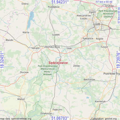
Sędziejowice GPS coordinates[2]
51° 30' 24.372" North, 19° 1' 39.468" East
| Map corner | latitude | longitude |
|---|---|---|
| Upper-left | 51.94231°, | 18.32451° |
| Center: | 51.50677°, | 19.02763° |
| Lower-right: | 51.06703°, | 19.73076° |
| Map W x H: | 97.3×97.3 km | = 60.5×60.5mi |
| max Lat: | 54.83135° ⇑43.5% North |
| Sędziejowice: | 51.50677° |
| min Lat: | ⇓56.5% South 49.21328° |
| min Long | Sędziejowice | max Long |
| 14.20249° | 19.02763° | 24.03723° |
| W 40.4%⇐ | ⇒59.6% E |
Elevation
Elevation of Sędziejowice is 171 m = 561 ft, and this is 20.4 m = 67 ft below average elevation for this country.
| Max E: |
974 m = 3196 ft | 50.2% |
| Avg. | 191.4 m = 628 ft | |
| Sędziejowice | 171 m = 561 ft | |
Min E: |
-3 m = -10 ft | 49.8% |
See also: Poland elevation on elevation.city.
Geographical zone
Sędziejowice is located in North temperate zone (between Tropic of Cancer and the Arctic Circle). Distance of this North polar circle is 1674.2 km =1040.3 mi to North.| Distance of | km | miles | from Sędziejowice |
|---|---|---|---|
| North Pole | 4280 | 2659.5 | to North |
| Arctic Circle | 1674.2 | 1040.3 | to North |
| Tropic Cancer | 3121.1 | 1939.4 | to South |
| Equator | 5727 | 3558.6 | to South |


Nearby cities:
15 places around Sędziejowice: (largest is in red/bold)
• Buczek
9.5 km =5.9 mi,  93°
93°
• Burzenin
14.5 km =9 mi,  249°
249°
• Dobroń
21 km =13 mi,  45°
45°
• Kluki
23.5 km =14.6 mi,  141°
141°
• Konopnica
22.1 km =13.7 mi,  219°
219°
• Rusiec
20.5 km =12.7 mi,  188°
188°
• Sieradz
22.8 km =14.2 mi,  295°
295°
• Szadek
20.9 km =13 mi,  350°
350°
• Szczerców
20.1 km =12.5 mi,  163°
163°
• Widawa
9.5 km =5.9 mi, 217°
• Wojsławice
17.7 km =11 mi,  336°
336°
• Zapolice
10.8 km =6.7 mi,  292°
292°
• Zduńska Wola
11.9 km =7.4 mi,  329°
329°
• Zelów
14.1 km =8.8 mi,  109°
109°
• Łask
11.8 km =7.3 mi,  37°
37°
Sources, notices
• [Note1] Compared only with cities in Poland existing in our database
• [Src1] Map data: © OpenStreetMap contributors (CC-BY-SA)
• [Src2] Other city data from geonames.org with taken over terms of usage.
• [Src3] Geographical zone / Annual Mean Temperature by Robert A. Rohde @ Wikipedia
