Zduńska Wola geodata
Zduńska Wola (Łódź Voivodeship) is a seat of a second-order administrative division; located in Poland in Europe/Warsaw (GMT+2) time zone. With population of 44,515 people, there are 115 cities with bigger population in this country. Compared to other cities in Poland, 58% of cities are located further ↓South; 61.1% of cities are located further →East and 53% of cities have lower elevation than Zduńska Wola. Note1
Administrative division(s):
- Level 1: Łódź Voivodeship
- Level 2: Powiat zduńskowolski
- Level 3: Zduńska Wola


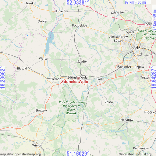
Zduńska Wola GPS coordinates[2]
51° 35' 56.94" North, 18° 56' 23.064" East
| Map corner | latitude | longitude |
|---|---|---|
| Upper-left | 52.03381°, | 18.23662° |
| Center: | 51.59915°, | 18.93974° |
| Lower-right: | 51.16029°, | 19.64287° |
| Map W x H: | 97.1×97.1 km | = 60.3×60.3mi |
| max Lat: | 54.83135° ⇑42% North |
| Zduńska Wola: | 51.59915° |
| min Lat: | ⇓58% South 49.21328° |
| min Long | Zduńska Wola | max Long |
| 14.20249° | 18.93974° | 24.03723° |
| W 38.9%⇐ | ⇒61.1% E |
Elevation
Elevation of Zduńska Wola is 180 m = 591 ft, and this is 11.4 m = 37 ft below average elevation for this country.
| Max E: |
974 m = 3196 ft | 47% |
| Avg. | 191.4 m = 628 ft | |
| Zduńska Wola | 180 m = 591 ft | |
Min E: |
-3 m = -10 ft | 53% |
See also: Zduńska Wola elevation on elevation.city.
Geographical zone
Zduńska Wola is located in North temperate zone (between Tropic of Cancer and the Arctic Circle). Distance of this North polar circle is 1663.9 km =1033.9 mi to North.| Distance of | km | miles | from Zduńska Wola |
|---|---|---|---|
| North Pole | 4269.8 | 2653.1 | to North |
| Arctic Circle | 1663.9 | 1033.9 | to North |
| Tropic Cancer | 3131.4 | 1945.8 | to South |
| Equator | 5737.3 | 3565 | to South |


Nearby cities:
15 places around Zduńska Wola: (largest is in red/bold)
• Brzeźnio
24.9 km =15.5 mi,  241°
241°
• Buczek
18.9 km =11.7 mi,  124°
124°
• Burzenin
17.1 km =10.6 mi,  205°
205°
• Dobroń
21.6 km =13.4 mi,  78°
78°
• Sieradz
14.5 km =9 mi,  268°
268°
• Szadek
10.6 km =6.6 mi,  13°
13°
• Sędziejowice
11.9 km =7.4 mi,  149°
149°
• Widawa
17.9 km =11.1 mi,  179°
179°
• Wodzierady
19.7 km =12.2 mi,  47°
47°
• Wojsławice
6 km =3.7 mi,  349°
349°
• Wróblew
22.5 km =14 mi, 273°
• Zadzim
20.7 km =12.9 mi,  342°
342°
• Zapolice
7.3 km =4.5 mi, 212°
• Zelów
24.5 km =15.2 mi,  127°
127°
• Łask
13.4 km =8.3 mi,  94°
94°
Sources, notices
• [Note1] Compared only with cities in Poland existing in our database
• [Src1] Map data: © OpenStreetMap contributors (CC-BY-SA)
• [Src2] Other city data from geonames.org with taken over terms of usage.
• [Src3] Geographical zone / Annual Mean Temperature by Robert A. Rohde @ Wikipedia
