Rusiec geodata
Rusiec (Łódź Voivodeship) is a seat of a third-order administrative division; located in Poland in Europe/Warsaw (GMT+2) time zone. With population of 1,500 people, there are 1837 cities with bigger population in this country. Compared to other cities in Poland, 53.6% of cities are located further ↓South; 60.3% of cities are located further →East and 54.2% of cities have higher elevation than Rusiec. Note1


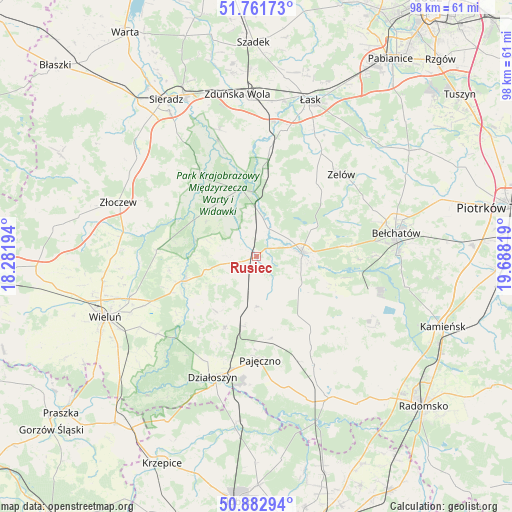
Rusiec GPS coordinates[2]
51° 19' 27.984" North, 18° 59' 6.216" East
| Map corner | latitude | longitude |
|---|---|---|
| Upper-left | 51.76173°, | 18.28194° |
| Center: | 51.32444°, | 18.98506° |
| Lower-right: | 50.88294°, | 19.68819° |
| Map W x H: | 97.7×97.7 km | = 60.7×60.7mi |
| max Lat: | 54.83135° ⇑46.4% North |
| Rusiec: | 51.32444° |
| min Lat: | ⇓53.6% South 49.21328° |
| min Long | Rusiec | max Long |
| 14.20249° | 18.98506° | 24.03723° |
| W 39.7%⇐ | ⇒60.3% E |
Elevation
Elevation of Rusiec is 161 m = 528 ft, and this is 30.4 m = 100 ft below average elevation for this country.
| Max E: |
974 m = 3196 ft | 54.2% |
| Avg. | 191.4 m = 628 ft | |
| Rusiec | 161 m = 528 ft | |
Min E: |
-3 m = -10 ft | 45.8% |
See also: Poland elevation on elevation.city.
Geographical zone
Rusiec is located in North temperate zone (between Tropic of Cancer and the Arctic Circle). Distance of this North polar circle is 1694.4 km =1052.9 mi to North.| Distance of | km | miles | from Rusiec |
|---|---|---|---|
| North Pole | 4300.3 | 2672.1 | to North |
| Arctic Circle | 1694.4 | 1052.9 | to North |
| Tropic Cancer | 3100.8 | 1926.7 | to South |
| Equator | 5706.7 | 3546 | to South |


Nearby cities:
15 places around Rusiec: (largest is in red/bold)
• Buczek
23.4 km =14.5 mi,  32°
32°
• Burzenin
18.5 km =11.5 mi,  325°
325°
• Kiełczygłów
9.5 km =5.9 mi,  180°
180°
• Kluki
17.8 km =11.1 mi,  83°
83°
• Konopnica
11.7 km =7.3 mi,  286°
286°
• Lipnik
12.9 km =8 mi,  218°
218°
• Osjaków
14 km =8.7 mi,  253°
253°
• Pajęczno
20 km =12.4 mi, 177°
• Rząśnia
12.3 km =7.6 mi,  160°
160°
• Siemkowice
14.9 km =9.3 mi,  203°
203°
• Sulmierzyce
21.4 km =13.3 mi,  136°
136°
• Szczerców
8.7 km =5.4 mi, 83°
• Sędziejowice
20.5 km =12.7 mi,  8°
8°
• Widawa
13 km =8.1 mi,  347°
347°
• Zelów
22.5 km =14 mi,  46°
46°
Sources, notices
• [Note1] Compared only with cities in Poland existing in our database
• [Src1] Map data: © OpenStreetMap contributors (CC-BY-SA)
• [Src2] Other city data from geonames.org with taken over terms of usage.
• [Src3] Geographical zone / Annual Mean Temperature by Robert A. Rohde @ Wikipedia
