Środa Wielkopolska geodata
Środa Wielkopolska (Greater Poland) is a seat of a second-order administrative division; located in Poland in Europe/Warsaw (GMT+2) time zone. With population of 21,757 people, there are 226 cities with bigger population in this country. Compared to other cities in Poland, 70.8% of cities are located further ↓South; 81.6% of cities are located further →East and 83.7% of cities have higher elevation than Środa Wielkopolska. Note1
Administrative division(s):
- Level 1: Greater Poland
- Level 2: Powiat średzki
- Level 3: Środa Wielkopolska


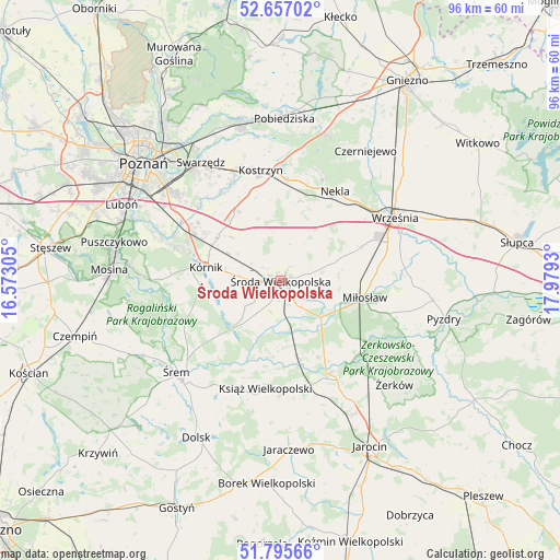
Środa Wielkopolska GPS coordinates[2]
52° 13' 42.348" North, 17° 16' 34.212" East
| Map corner | latitude | longitude |
|---|---|---|
| Upper-left | 52.65702°, | 16.57305° |
| Center: | 52.22843°, | 17.27617° |
| Lower-right: | 51.79566°, | 17.9793° |
| Map W x H: | 95.8×95.8 km | = 59.5×59.5mi |
| max Lat: | 54.83135° ⇑29.2% North |
| Środa Wielkopolska: | 52.22843° |
| min Lat: | ⇓70.8% South 49.21328° |
| min Long | Środa Wielkopo | max Long |
| 14.20249° | 17.27617° | 24.03723° |
| W 18.4%⇐ | ⇒81.6% E |
Elevation
Elevation of Środa Wielkopolska is 92 m = 302 ft, and this is 99.4 m = 326 ft below average elevation for this country.
| Max E: |
974 m = 3196 ft | 83.7% |
| Avg. | 191.4 m = 628 ft | |
| Środa Wielkopolska | 92 m = 302 ft | |
Min E: |
-3 m = -10 ft | 16.3% |
See also: Poland elevation on elevation.city.
Geographical zone
Środa Wielkopolska is located in North temperate zone (between Tropic of Cancer and the Arctic Circle). Distance of this North polar circle is 1593.9 km =990.4 mi to North.| Distance of | km | miles | from Środa Wielkopolska |
|---|---|---|---|
| North Pole | 4199.8 | 2609.6 | to North |
| Arctic Circle | 1593.9 | 990.4 | to North |
| Tropic Cancer | 3201.3 | 1989.2 | to South |
| Equator | 5807.3 | 3608.5 | to South |


Nearby cities:
15 places around Środa Wielkopolska: (largest is in red/bold)
• Dominowo
8.9 km =5.5 mi,  38°
38°
• Gądki
18.2 km =11.3 mi,  300°
300°
• Kleszczewo
13.7 km =8.5 mi,  328°
328°
• Kostrzyn
19.2 km =11.9 mi,  350°
350°
• Krzykosy
14.7 km =9.1 mi,  153°
153°
• Książ Wielkopolski
18.7 km =11.6 mi,  187°
187°
• Kórnik
12.9 km =8 mi,  279°
279°
• Miłosław
14.8 km =9.2 mi,  100°
100°
• Nekla
17.8 km =11.1 mi,  31°
31°
• Nowe Miasto nad Wartą
17.9 km =11.1 mi, 149°
• Rogalin
23.1 km =14.4 mi,  271°
271°
• Solec
14 km =8.7 mi,  165°
165°
• Słupia Wiełka
4 km =2.5 mi,  253°
253°
• Września
22.4 km =13.9 mi,  61°
61°
• Zaniemyśl
11.2 km =7 mi,  223°
223°
Sources, notices
• [Note1] Compared only with cities in Poland existing in our database
• [Src1] Map data: © OpenStreetMap contributors (CC-BY-SA)
• [Src2] Other city data from geonames.org with taken over terms of usage.
• [Src3] Geographical zone / Annual Mean Temperature by Robert A. Rohde @ Wikipedia
