Dominowo geodata
Dominowo (Greater Poland) is a seat of a third-order administrative division; located in Poland in Europe/Warsaw (GMT+2) time zone. With population of 547 people, there are 3418 cities with bigger population in this country. Compared to other cities in Poland, 72.2% of cities are located further ↓South; 81.1% of cities are located further →East and 79.8% of cities have higher elevation than Dominowo. Note1


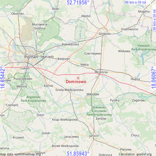
Dominowo GPS coordinates[2]
52° 17' 29.688" North, 17° 21' 27.144" East
| Map corner | latitude | longitude |
|---|---|---|
| Upper-left | 52.71956°, | 16.65442° |
| Center: | 52.29158°, | 17.35754° |
| Lower-right: | 51.85943°, | 18.06067° |
| Map W x H: | 95.6×95.6 km | = 59.4×59.4mi |
| max Lat: | 54.83135° ⇑27.8% North |
| Dominowo: | 52.29158° |
| min Lat: | ⇓72.2% South 49.21328° |
| min Long | Dominowo | max Long |
| 14.20249° | 17.35754° | 24.03723° |
| W 18.9%⇐ | ⇒81.1% E |
Elevation
Elevation of Dominowo is 100 m = 328 ft, and this is 91.4 m = 300 ft below average elevation for this country.
| Max E: |
974 m = 3196 ft | 79.8% |
| Avg. | 191.4 m = 628 ft | |
| Dominowo | 100 m = 328 ft | |
Min E: |
-3 m = -10 ft | 20.2% |
See also: Poland elevation on elevation.city.
Geographical zone
Dominowo is located in North temperate zone (between Tropic of Cancer and the Arctic Circle). Distance of this North polar circle is 1586.9 km =986.1 mi to North.| Distance of | km | miles | from Dominowo |
|---|---|---|---|
| North Pole | 4192.8 | 2605.3 | to North |
| Arctic Circle | 1586.9 | 986.1 | to North |
| Tropic Cancer | 3208.4 | 1993.6 | to South |
| Equator | 5814.3 | 3612.8 | to South |


Nearby cities:
15 places around Dominowo: (largest is in red/bold)
• Czerniejewo
17.5 km =10.9 mi,  30°
30°
• Grabowo Królewskie
18.8 km =11.7 mi,  107°
107°
• Gądki
21.2 km =13.2 mi,  276°
276°
• Kleszczewo
13.5 km =8.4 mi,  290°
290°
• Kostrzyn
14.8 km =9.2 mi,  323°
323°
• Kołaczkowo
19.9 km =12.4 mi, 114°
• Krzykosy
20.2 km =12.6 mi,  176°
176°
• Kórnik
18.9 km =11.7 mi,  255°
255°
• Miłosław
13.3 km =8.3 mi,  137°
137°
• Nekla
9 km =5.6 mi,  24°
24°
• Solec
20.6 km =12.8 mi,  185°
185°
• Słupia Wiełka
12.5 km =7.8 mi,  228°
228°
• Września
14.6 km =9.1 mi,  75°
75°
• Zaniemyśl
20.1 km =12.5 mi,  221°
221°
• Środa Wielkopolska
8.9 km =5.5 mi, 218°
Sources, notices
• [Note1] Compared only with cities in Poland existing in our database
• [Src1] Map data: © OpenStreetMap contributors (CC-BY-SA)
• [Src2] Other city data from geonames.org with taken over terms of usage.
• [Src3] Geographical zone / Annual Mean Temperature by Robert A. Rohde @ Wikipedia
