Zagórnik geodata
Zagórnik (Lesser Poland) is a populated place; located in Poland in Europe/Warsaw (GMT+2) time zone. With population of 2,119 people, there are 1404 cities with bigger population in this country. Compared to other cities in Poland, 90.3% of cities are located further ↑North; 53.1% of cities are located further →East and 93.3% of cities have lower elevation than Zagórnik. Note1


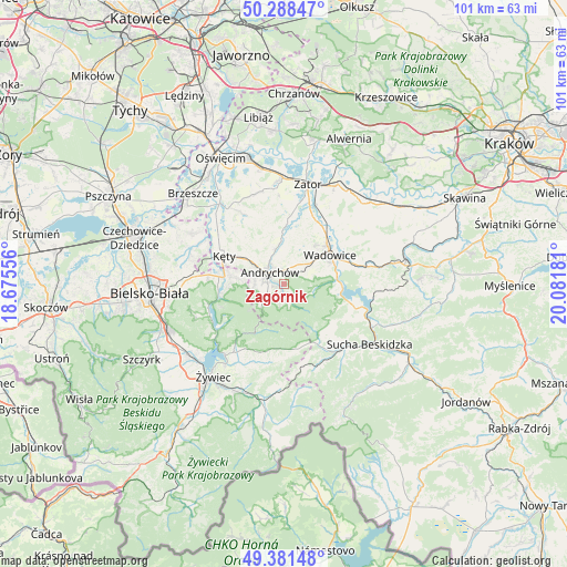
Zagórnik GPS coordinates[2]
49° 50' 13.56" North, 19° 22' 43.248" East
| Map corner | latitude | longitude |
|---|---|---|
| Upper-left | 50.28847°, | 18.67556° |
| Center: | 49.8371°, | 19.37868° |
| Lower-right: | 49.38148°, | 20.08181° |
| Map W x H: | 100.8×100.8 km | = 62.6×62.6mi |
| max Lat: | 54.83135° ⇑90.3% North |
| Zagórnik: | 49.8371° |
| min Lat: | ⇓9.7% South 49.21328° |
| min Long | Zagórnik | max Long |
| 14.20249° | 19.37868° | 24.03723° |
| W 46.9%⇐ | ⇒53.1% E |
Elevation
Elevation of Zagórnik is 377 m = 1237 ft, and this is 185.6 m = 609 ft above average elevation for this country.
| Max E: |
974 m = 3196 ft | 6.7% |
| Zagórnik | 377 m 1237 ft | |
| Avg. | 191.4 m = 628 ft | |
Min E: |
-3 m = -10 ft | 93.3% |
See also: Poland elevation on elevation.city.
Geographical zone
Zagórnik is located in North temperate zone (between Tropic of Cancer and the Arctic Circle). Distance of this North polar circle is 1859.8 km =1155.6 mi to North.| Distance of | km | miles | from Zagórnik |
|---|---|---|---|
| North Pole | 4465.7 | 2774.9 | to North |
| Arctic Circle | 1859.8 | 1155.6 | to North |
| Tropic Cancer | 2935.4 | 1824 | to South |
| Equator | 5541.4 | 3443.3 | to South |


Nearby cities:
15 places around Zagórnik: (largest is in red/bold)
• Andrychów
3.5 km =2.2 mi,  304°
304°
• Brzezinka
5.2 km =3.2 mi,  271°
271°
• Bulowice
7.8 km =4.8 mi, 304°
• Chocznia
6.8 km =4.2 mi,  52°
52°
• Czaniec
9.1 km =5.7 mi,  279°
279°
• Frydrychowice
8.1 km =5 mi,  21°
21°
• Inwałd
3.1 km =1.9 mi, 18°
• Nidek
8.5 km =5.3 mi,  332°
332°
• Ponikiew
6.3 km =3.9 mi,  94°
94°
• Roczyny
4.9 km =3 mi,  292°
292°
• Rzyki
3.1 km =1.9 mi,  156°
156°
• Sułkowice
2.4 km =1.5 mi,  214°
214°
• Targanice
5.2 km =3.2 mi,  228°
228°
• Wadowice
9.7 km =6 mi,  57°
57°
• Wieprz
6.2 km =3.9 mi,  345°
345°
Sources, notices
• [Note1] Compared only with cities in Poland existing in our database
• [Src1] Map data: © OpenStreetMap contributors (CC-BY-SA)
• [Src2] Other city data from geonames.org with taken over terms of usage.
• [Src3] Geographical zone / Annual Mean Temperature by Robert A. Rohde @ Wikipedia
