Ponikiew geodata
Ponikiew (Lesser Poland) is a populated place; located in Poland in Europe/Warsaw (GMT+2) time zone. With population of 1,237 people, there are 2140 cities with bigger population in this country. Compared to other cities in Poland, 90.5% of cities are located further ↑North; 51.6% of cities are located further →East and 91.2% of cities have lower elevation than Ponikiew. Note1


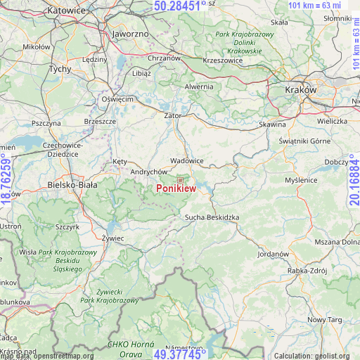
Ponikiew GPS coordinates[2]
49° 49' 59.196" North, 19° 27' 56.556" East
| Map corner | latitude | longitude |
|---|---|---|
| Upper-left | 50.28451°, | 18.76259° |
| Center: | 49.83311°, | 19.46571° |
| Lower-right: | 49.37745°, | 20.16884° |
| Map W x H: | 100.9×100.9 km | = 62.7×62.7mi |
| max Lat: | 54.83135° ⇑90.5% North |
| Ponikiew: | 49.83311° |
| min Lat: | ⇓9.5% South 49.21328° |
| min Long | Ponikiew | max Long |
| 14.20249° | 19.46571° | 24.03723° |
| W 48.4%⇐ | ⇒51.6% E |
Elevation
Elevation of Ponikiew is 347 m = 1138 ft, and this is 155.6 m = 510 ft above average elevation for this country.
| Max E: |
974 m = 3196 ft | 8.8% |
| Ponikiew | 347 m 1138 ft | |
| Avg. | 191.4 m = 628 ft | |
Min E: |
-3 m = -10 ft | 91.2% |
See also: Poland elevation on elevation.city.
Geographical zone
Ponikiew is located in North temperate zone (between Tropic of Cancer and the Arctic Circle). Distance of this North polar circle is 1860.3 km =1155.9 mi to North.| Distance of | km | miles | from Ponikiew |
|---|---|---|---|
| North Pole | 4466.1 | 2775.1 | to North |
| Arctic Circle | 1860.3 | 1155.9 | to North |
| Tropic Cancer | 2935 | 1823.7 | to South |
| Equator | 5540.9 | 3443 | to South |


Nearby cities:
15 places around Ponikiew: (largest is in red/bold)
• Barwałd Dolny
8.4 km =5.2 mi,  63°
63°
• Chocznia
4.6 km =2.9 mi,  349°
349°
• Frydrychowice
8.6 km =5.3 mi,  337°
337°
• Inwałd
6.2 km =3.9 mi,  302°
302°
• Jaroszowice
5.1 km =3.2 mi,  49°
49°
• Klecza Dolna
7.6 km =4.7 mi,  42°
42°
• Klecza Górna
7.4 km =4.6 mi, 61°
• Krzeszów
8.4 km =5.2 mi,  168°
168°
• Mucharz
6.3 km =3.9 mi,  111°
111°
• Rzyki
5.5 km =3.4 mi,  244°
244°
• Sułkowice
7.7 km =4.8 mi,  258°
258°
• Tomice
7.3 km =4.5 mi,  10°
10°
• Wadowice
5.9 km =3.7 mi,  19°
19°
• Zagórnik
6.3 km =3.9 mi,  274°
274°
• Świnna Poręba
4 km =2.5 mi,  84°
84°
Sources, notices
• [Note1] Compared only with cities in Poland existing in our database
• [Src1] Map data: © OpenStreetMap contributors (CC-BY-SA)
• [Src2] Other city data from geonames.org with taken over terms of usage.
• [Src3] Geographical zone / Annual Mean Temperature by Robert A. Rohde @ Wikipedia
