Rzyki geodata
Rzyki (Lesser Poland) is a populated place; located in Poland in Europe/Warsaw (GMT+2) time zone. With population of 3,105 people, there are 1017 cities with bigger population in this country. Compared to other cities in Poland, 91.4% of cities are located further ↑North; 52.8% of cities are located further →East and 95.1% of cities have lower elevation than Rzyki. Note1


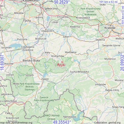
Rzyki GPS coordinates[2]
49° 48' 40.644" North, 19° 23' 46.284" East
| Map corner | latitude | longitude |
|---|---|---|
| Upper-left | 50.2629°, | 18.69307° |
| Center: | 49.81129°, | 19.39619° |
| Lower-right: | 49.35543°, | 20.09932° |
| Map W x H: | 100.9×100.9 km | = 62.7×62.7mi |
| max Lat: | 54.83135° ⇑91.4% North |
| Rzyki: | 49.81129° |
| min Lat: | ⇓8.6% South 49.21328° |
| min Long | Rzyki | max Long |
| 14.20249° | 19.39619° | 24.03723° |
| W 47.2%⇐ | ⇒52.8% E |
Elevation
Elevation of Rzyki is 419 m = 1375 ft, and this is 227.6 m = 747 ft above average elevation for this country.
| Max E: |
974 m = 3196 ft | 4.9% |
| Rzyki | 419 m 1375 ft | |
| Avg. | 191.4 m = 628 ft | |
Min E: |
-3 m = -10 ft | 95.1% |
See also: Poland elevation on elevation.city.
Geographical zone
Rzyki is located in North temperate zone (between Tropic of Cancer and the Arctic Circle). Distance of this North polar circle is 1862.7 km =1157.4 mi to North.| Distance of | km | miles | from Rzyki |
|---|---|---|---|
| North Pole | 4468.6 | 2776.7 | to North |
| Arctic Circle | 1862.7 | 1157.4 | to North |
| Tropic Cancer | 2932.6 | 1822.2 | to South |
| Equator | 5538.5 | 3441.5 | to South |


Nearby cities:
15 places around Rzyki: (largest is in red/bold)
• Andrychów
6.4 km =4 mi,  319°
319°
• Brzezinka
7.1 km =4.4 mi,  294°
294°
• Chocznia
8.1 km =5 mi,  30°
30°
• Frydrychowice
10.5 km =6.5 mi,  9°
9°
• Inwałd
5.8 km =3.6 mi,  357°
357°
• Jaroszowice
10.5 km =6.5 mi,  57°
57°
• Krzeszów
8.8 km =5.5 mi,  130°
130°
• Kurów
10.4 km =6.5 mi,  164°
164°
• Ponikiew
5.5 km =3.4 mi, 64°
• Roczyny
7.5 km =4.7 mi,  309°
309°
• Sułkowice
2.8 km =1.7 mi, 288°
• Targanice
5.2 km =3.2 mi,  263°
263°
• Wieprz
9.3 km =5.8 mi,  342°
342°
• Zagórnik
3.1 km =1.9 mi, 336°
• Świnna Poręba
9.4 km =5.8 mi,  72°
72°
Sources, notices
• [Note1] Compared only with cities in Poland existing in our database
• [Src1] Map data: © OpenStreetMap contributors (CC-BY-SA)
• [Src2] Other city data from geonames.org with taken over terms of usage.
• [Src3] Geographical zone / Annual Mean Temperature by Robert A. Rohde @ Wikipedia
