Wadowice geodata
Wadowice (Lesser Poland) is a seat of a second-order administrative division; located in Poland in Europe/Warsaw (GMT+2) time zone. With population of 19,238 people, there are 249 cities with bigger population in this country. Compared to other cities in Poland, 88.3% of cities are located further ↑North; 51% of cities are located further →East and 81.2% of cities have lower elevation than Wadowice. Note1


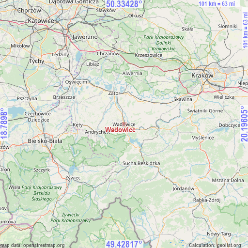
Wadowice GPS coordinates[2]
49° 53' 0.06" North, 19° 29' 34.512" East
| Map corner | latitude | longitude |
|---|---|---|
| Upper-left | 50.33428°, | 18.7898° |
| Center: | 49.88335°, | 19.49292° |
| Lower-right: | 49.42817°, | 20.19605° |
| Map W x H: | 100.7×100.7 km | = 62.6×62.6mi |
| max Lat: | 54.83135° ⇑88.3% North |
| Wadowice: | 49.88335° |
| min Lat: | ⇓11.7% South 49.21328° |
| min Long | Wadowice | max Long |
| 14.20249° | 19.49292° | 24.03723° |
| W 49%⇐ | ⇒51% E |
Elevation
Elevation of Wadowice is 271 m = 889 ft, and this is 79.6 m = 261 ft above average elevation for this country.
| Max E: |
974 m = 3196 ft | 18.8% |
| Wadowice | 271 m 889 ft | |
| Avg. | 191.4 m = 628 ft | |
Min E: |
-3 m = -10 ft | 81.2% |
See also: Poland elevation on elevation.city.
Geographical zone
Wadowice is located in North temperate zone (between Tropic of Cancer and the Arctic Circle). Distance of this North polar circle is 1854.7 km =1152.5 mi to North.| Distance of | km | miles | from Wadowice |
|---|---|---|---|
| North Pole | 4460.6 | 2771.7 | to North |
| Arctic Circle | 1854.7 | 1152.5 | to North |
| Tropic Cancer | 2940.6 | 1827.2 | to South |
| Equator | 5546.5 | 3446.4 | to South |


Nearby cities:
15 places around Wadowice: (largest is in red/bold)
• Barwałd Dolny
5.9 km =3.7 mi,  108°
108°
• Barwałd Średni
7.5 km =4.7 mi,  104°
104°
• Chocznia
2.9 km =1.8 mi,  249°
249°
• Frydrychowice
5.8 km =3.6 mi,  294°
294°
• Graboszyce
7.6 km =4.7 mi,  335°
335°
• Inwałd
7.5 km =4.7 mi, 252°
• Jaroszowice
3 km =1.9 mi,  140°
140°
• Klecza Dolna
3.2 km =2 mi,  90°
90°
• Klecza Górna
5 km =3.1 mi, 114°
• Ponikiew
5.9 km =3.7 mi,  199°
199°
• Radocza
4 km =2.5 mi, 341°
• Tomice
1.7 km =1.1 mi, 337°
• Witanowice
4.5 km =2.8 mi,  31°
31°
• Woźniki
6 km =3.7 mi,  358°
358°
• Świnna Poręba
5.6 km =3.5 mi,  158°
158°
Sources, notices
• [Note1] Compared only with cities in Poland existing in our database
• [Src1] Map data: © OpenStreetMap contributors (CC-BY-SA)
• [Src2] Other city data from geonames.org with taken over terms of usage.
• [Src3] Geographical zone / Annual Mean Temperature by Robert A. Rohde @ Wikipedia
