Czarków geodata
Czarków (Silesia) is a populated place; located in Poland in Europe/Warsaw (GMT+2) time zone. With population of 1,924 people, there are 1538 cities with bigger population in this country. Compared to other cities in Poland, 81.4% of cities are located further ↑North; 61.8% of cities are located further →East and 76.5% of cities have lower elevation than Czarków. Note1


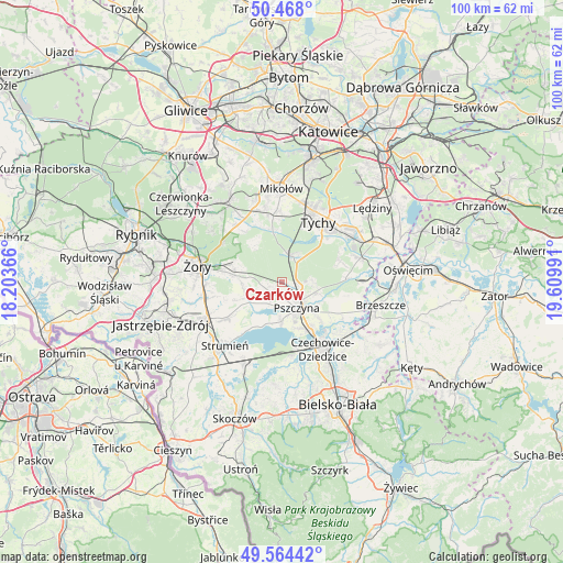
Czarków GPS coordinates[2]
50° 1' 5.988" North, 18° 54' 24.408" East
| Map corner | latitude | longitude |
|---|---|---|
| Upper-left | 50.468°, | 18.20366° |
| Center: | 50.01833°, | 18.90678° |
| Lower-right: | 49.56442°, | 19.60991° |
| Map W x H: | 100.5×100.5 km | = 62.4×62.4mi |
| max Lat: | 54.83135° ⇑81.4% North |
| Czarków: | 50.01833° |
| min Lat: | ⇓18.6% South 49.21328° |
| min Long | Czarków | max Long |
| 14.20249° | 18.90678° | 24.03723° |
| W 38.2%⇐ | ⇒61.8% E |
Elevation
Elevation of Czarków is 252 m = 827 ft, and this is 60.6 m = 199 ft above average elevation for this country.
| Max E: |
974 m = 3196 ft | 23.5% |
| Czarków | 252 m 827 ft | |
| Avg. | 191.4 m = 628 ft | |
Min E: |
-3 m = -10 ft | 76.5% |
See also: Poland elevation on elevation.city.
Geographical zone
Czarków is located in North temperate zone (between Tropic of Cancer and the Arctic Circle). Distance of this North polar circle is 1839.7 km =1143.1 mi to North.| Distance of | km | miles | from Czarków |
|---|---|---|---|
| North Pole | 4445.5 | 2762.3 | to North |
| Arctic Circle | 1839.7 | 1143.1 | to North |
| Tropic Cancer | 2955.6 | 1836.5 | to South |
| Equator | 5561.5 | 3455.8 | to South |


Nearby cities:
15 places around Czarków: (largest is in red/bold)
• Bojszowy Nowe
10.9 km =6.8 mi,  69°
69°
• Cielmice
11.2 km =7 mi,  45°
45°
• Goczałkowice Zdrój
9.3 km =5.8 mi,  151°
151°
• Gostyń
9.8 km =6.1 mi,  349°
349°
• Jankowice
6.2 km =3.9 mi,  108°
108°
• Kobiór
5.1 km =3.2 mi,  22°
22°
• Kryry
7.2 km =4.5 mi,  268°
268°
• Miedźna
10.9 km =6.8 mi, 111°
• Międzyrzecze
11.3 km =7 mi,  86°
86°
• Piasek
3.1 km =1.9 mi, 106°
• Pszczyna
5.4 km =3.4 mi,  141°
141°
• Radostowice
2.5 km =1.6 mi,  227°
227°
• Rudziczka
10.5 km =6.5 mi,  280°
280°
• Studzionka
11.4 km =7.1 mi,  236°
236°
• Suszec
8.3 km =5.2 mi, 278°
Sources, notices
• [Note1] Compared only with cities in Poland existing in our database
• [Src1] Map data: © OpenStreetMap contributors (CC-BY-SA)
• [Src2] Other city data from geonames.org with taken over terms of usage.
• [Src3] Geographical zone / Annual Mean Temperature by Robert A. Rohde @ Wikipedia
