Międzyrzecze geodata
Międzyrzecze (Silesia) is a populated place; located in Poland in Europe/Warsaw (GMT+2) time zone. With population of 754 people, there are 2942 cities with bigger population in this country. Compared to other cities in Poland, 81.2% of cities are located further ↑North; 58.9% of cities are located further →East and 72.4% of cities have lower elevation than Międzyrzecze. Note1


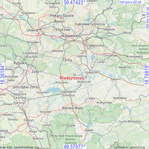
Międzyrzecze GPS coordinates[2]
50° 1' 28.632" North, 19° 3' 54.216" East
| Map corner | latitude | longitude |
|---|---|---|
| Upper-left | 50.47423°, | 18.36194° |
| Center: | 50.02462°, | 19.06506° |
| Lower-right: | 49.57077°, | 19.76819° |
| Map W x H: | 100.5×100.5 km | = 62.4×62.4mi |
| max Lat: | 54.83135° ⇑81.2% North |
| Międzyrzecze: | 50.02462° |
| min Lat: | ⇓18.8% South 49.21328° |
| min Long | Międzyrzecze | max Long |
| 14.20249° | 19.06506° | 24.03723° |
| W 41.1%⇐ | ⇒58.9% E |
Elevation
Elevation of Międzyrzecze is 237 m = 778 ft, and this is 45.6 m = 150 ft above average elevation for this country.
| Max E: |
974 m = 3196 ft | 27.6% |
| Międzyrzecze | 237 m 778 ft | |
| Avg. | 191.4 m = 628 ft | |
Min E: |
-3 m = -10 ft | 72.4% |
See also: Poland elevation on elevation.city.
Geographical zone
Międzyrzecze is located in North temperate zone (between Tropic of Cancer and the Arctic Circle). Distance of this North polar circle is 1839 km =1142.7 mi to North.| Distance of | km | miles | from Międzyrzecze |
|---|---|---|---|
| North Pole | 4444.8 | 2761.9 | to North |
| Arctic Circle | 1839 | 1142.7 | to North |
| Tropic Cancer | 2956.3 | 1837 | to South |
| Equator | 5562.2 | 3456.2 | to South |


Nearby cities:
15 places around Międzyrzecze: (largest is in red/bold)
• Bieruń
7.5 km =4.7 mi,  15°
15°
• Bojszowy
4.5 km =2.8 mi,  35°
35°
• Bojszowy Nowe
3.3 km =2.1 mi,  341°
341°
• Brzeszcze
7.8 km =4.8 mi,  127°
127°
• Cielmice
7.8 km =4.8 mi, 335°
• Frydek
3.2 km =2 mi,  170°
170°
• Gilowice
4 km =2.5 mi,  145°
145°
• Góra
5.7 km =3.5 mi, 150°
• Harmęże
7 km =4.3 mi,  93°
93°
• Jankowice
6 km =3.7 mi,  244°
244°
• Kaniów
9.1 km =5.7 mi,  186°
186°
• Miedźna
4.9 km =3 mi, 193°
• Piasek
8.5 km =5.3 mi,  259°
259°
• Przecieszyn
9.1 km =5.7 mi,  124°
124°
• Wola
4.2 km =2.6 mi,  100°
100°
Sources, notices
• [Note1] Compared only with cities in Poland existing in our database
• [Src1] Map data: © OpenStreetMap contributors (CC-BY-SA)
• [Src2] Other city data from geonames.org with taken over terms of usage.
• [Src3] Geographical zone / Annual Mean Temperature by Robert A. Rohde @ Wikipedia
