Tłuchowo geodata
Tłuchowo (Kujawsko-Pomorskie) is a seat of a third-order administrative division; located in Poland in Europe/Warsaw (GMT+2) time zone. With population of 1,159 people, there are 2247 cities with bigger population in this country. Compared to other cities in Poland, 80.1% of cities are located further ↓South; 51.6% of cities are located further →East and 80.6% of cities have higher elevation than Tłuchowo. Note1


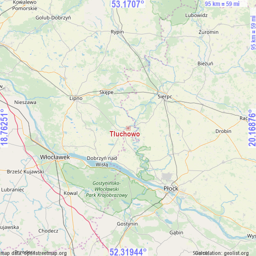
Tłuchowo GPS coordinates[2]
52° 44' 49.74" North, 19° 27' 56.268" East
| Map corner | latitude | longitude |
|---|---|---|
| Upper-left | 53.1707°, | 18.76251° |
| Center: | 52.74715°, | 19.46563° |
| Lower-right: | 52.31944°, | 20.16876° |
| Map W x H: | 94.7×94.6 km | = 58.8×58.8mi |
| max Lat: | 54.83135° ⇑19.9% North |
| Tłuchowo: | 52.74715° |
| min Lat: | ⇓80.1% South 49.21328° |
| min Long | Tłuchowo | max Long |
| 14.20249° | 19.46563° | 24.03723° |
| W 48.4%⇐ | ⇒51.6% E |
Elevation
Elevation of Tłuchowo is 98 m = 322 ft, and this is 93.4 m = 306 ft below average elevation for this country.
| Max E: |
974 m = 3196 ft | 80.6% |
| Avg. | 191.4 m = 628 ft | |
| Tłuchowo | 98 m = 322 ft | |
Min E: |
-3 m = -10 ft | 19.4% |
See also: Poland elevation on elevation.city.
Geographical zone
Tłuchowo is located in North temperate zone (between Tropic of Cancer and the Arctic Circle). Distance of this North polar circle is 1536.2 km =954.6 mi to North.| Distance of | km | miles | from Tłuchowo |
|---|---|---|---|
| North Pole | 4142.1 | 2573.8 | to North |
| Arctic Circle | 1536.2 | 954.6 | to North |
| Tropic Cancer | 3259 | 2025 | to South |
| Equator | 5864.9 | 3644.3 | to South |


Nearby cities:
15 places around Tłuchowo: (largest is in red/bold)
• Biała
20.1 km =12.5 mi,  141°
141°
• Bielsk
24.3 km =15.1 mi,  110°
110°
• Brudzeń Duży
9.1 km =5.7 mi,  163°
163°
• Dobrzyń nad Wisłą
15.6 km =9.7 mi,  219°
219°
• Fabianki
24.2 km =15 mi,  262°
262°
• Gozdowo
15 km =9.3 mi,  99°
99°
• Lipno
22.1 km =13.7 mi,  299°
299°
• Maszewo Duże
21.6 km =13.4 mi,  149°
149°
• Mochowo
6.4 km =4 mi,  71°
71°
• Nowy Duninów
18.3 km =11.4 mi,  176°
176°
• Sierpc
18.3 km =11.4 mi,  48°
48°
• Skępe
15.3 km =9.5 mi,  331°
331°
• Szczutowo
22.7 km =14.1 mi,  18°
18°
• Wielgie
13.6 km =8.5 mi,  267°
267°
• Witkowo
19.3 km =12 mi, 274°
Sources, notices
• [Note1] Compared only with cities in Poland existing in our database
• [Src1] Map data: © OpenStreetMap contributors (CC-BY-SA)
• [Src2] Other city data from geonames.org with taken over terms of usage.
• [Src3] Geographical zone / Annual Mean Temperature by Robert A. Rohde @ Wikipedia
