Chrostkowo geodata
Chrostkowo (Kujawsko-Pomorskie) is a seat of a third-order administrative division; located in Poland in Europe/Warsaw (GMT+2) time zone. With population of 314 people, there are 3616 cities with bigger population in this country. Compared to other cities in Poland, 82.9% of cities are located further ↓South; 55.1% of cities are located further →East and 74% of cities have higher elevation than Chrostkowo. Note1
Administrative division(s):
- Level 1: Kujawsko-Pomorskie
- Level 2: Powiat lipnowski
- Level 3: Chrostkowo


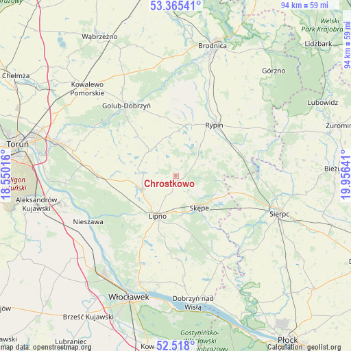
Chrostkowo GPS coordinates[2]
52° 56' 37.608" North, 19° 15' 11.808" East
| Map corner | latitude | longitude |
|---|---|---|
| Upper-left | 53.36541°, | 18.55016° |
| Center: | 52.94378°, | 19.25328° |
| Lower-right: | 52.518°, | 19.95641° |
| Map W x H: | 94.2×94.2 km | = 58.5×58.5mi |
| max Lat: | 54.83135° ⇑17.1% North |
| Chrostkowo: | 52.94378° |
| min Lat: | ⇓82.9% South 49.21328° |
| min Long | Chrostkowo | max Long |
| 14.20249° | 19.25328° | 24.03723° |
| W 44.9%⇐ | ⇒55.1% E |
Elevation
Elevation of Chrostkowo is 113 m = 371 ft, and this is 78.4 m = 257 ft below average elevation for this country.
| Max E: |
974 m = 3196 ft | 74% |
| Avg. | 191.4 m = 628 ft | |
| Chrostkowo | 113 m = 371 ft | |
Min E: |
-3 m = -10 ft | 26% |
See also: Poland elevation on elevation.city.
Geographical zone
Chrostkowo is located in North temperate zone (between Tropic of Cancer and the Arctic Circle). Distance of this North polar circle is 1514.4 km =941 mi to North.| Distance of | km | miles | from Chrostkowo |
|---|---|---|---|
| North Pole | 4120.3 | 2560.2 | to North |
| Arctic Circle | 1514.4 | 941 | to North |
| Tropic Cancer | 3280.9 | 2038.7 | to South |
| Equator | 5886.8 | 3657.9 | to South |


Nearby cities:
15 places around Chrostkowo: (largest is in red/bold)
• Brzuze
12.3 km =7.6 mi,  2°
2°
• Czernikowo
21.1 km =13.1 mi,  270°
270°
• Kikół
9.7 km =6 mi,  247°
247°
• Lipno
12.1 km =7.5 mi,  204°
204°
• Lubin
9.7 km =6 mi, 265°
• Ostrowite
14.2 km =8.8 mi,  10°
10°
• Radomin
16.4 km =10.2 mi,  346°
346°
• Rogowo
9.6 km =6 mi,  67°
67°
• Rypin
17.1 km =10.6 mi,  37°
37°
• Skępe
10.9 km =6.8 mi,  140°
140°
• Szczutowo
21.5 km =13.4 mi,  90°
90°
• Wielgie
12.1 km =7.5 mi,  302°
302°
• Witkowo
21 km =13 mi,  193°
193°
• Wąpielsk
21.6 km =13.4 mi, 4°
• Zbójno
9.6 km =6 mi,  318°
318°
Sources, notices
• [Note1] Compared only with cities in Poland existing in our database
• [Src1] Map data: © OpenStreetMap contributors (CC-BY-SA)
• [Src2] Other city data from geonames.org with taken over terms of usage.
• [Src3] Geographical zone / Annual Mean Temperature by Robert A. Rohde @ Wikipedia
