Łubianka geodata
Łubianka (Kujawsko-Pomorskie) is a seat of a third-order administrative division; located in Poland in Europe/Warsaw (GMT+2) time zone. With population of 953 people, there are 2588 cities with bigger population in this country. Compared to other cities in Poland, 85.4% of cities are located further ↓South; 68.5% of cities are located further →East and 89.9% of cities have higher elevation than Łubianka. Note1


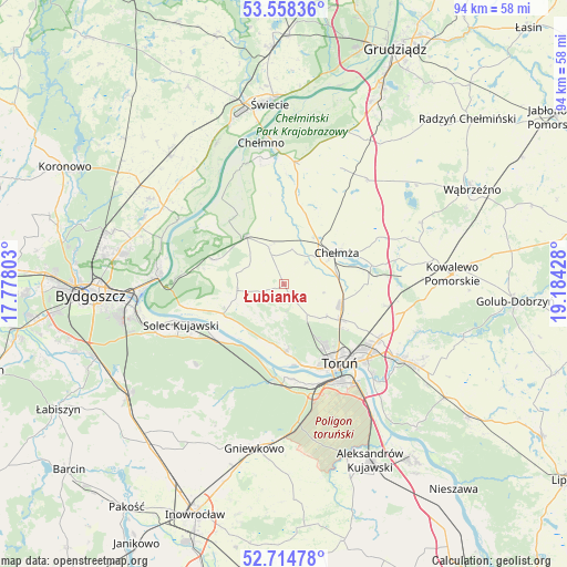
Łubianka GPS coordinates[2]
53° 8' 19.104" North, 18° 28' 52.14" East
| Map corner | latitude | longitude |
|---|---|---|
| Upper-left | 53.55836°, | 17.77803° |
| Center: | 53.13864°, | 18.48115° |
| Lower-right: | 52.71478°, | 19.18428° |
| Map W x H: | 93.8×93.8 km | = 58.3×58.3mi |
| max Lat: | 54.83135° ⇑14.6% North |
| Łubianka: | 53.13864° |
| min Lat: | ⇓85.4% South 49.21328° |
| min Long | Łubianka | max Long |
| 14.20249° | 18.48115° | 24.03723° |
| W 31.5%⇐ | ⇒68.5% E |
Elevation
Elevation of Łubianka is 76 m = 249 ft, and this is 115.4 m = 379 ft below average elevation for this country.
| Max E: |
974 m = 3196 ft | 89.9% |
| Avg. | 191.4 m = 628 ft | |
| Łubianka | 76 m = 249 ft | |
Min E: |
-3 m = -10 ft | 10.1% |
See also: Poland elevation on elevation.city.
Geographical zone
Łubianka is located in North temperate zone (between Tropic of Cancer and the Arctic Circle). Distance of this North polar circle is 1492.7 km =927.5 mi to North.| Distance of | km | miles | from Łubianka |
|---|---|---|---|
| North Pole | 4098.6 | 2546.8 | to North |
| Arctic Circle | 1492.7 | 927.5 | to North |
| Tropic Cancer | 3302.5 | 2052.1 | to South |
| Equator | 5908.5 | 3671.4 | to South |


Nearby cities:
15 places around Łubianka: (largest is in red/bold)
• Chełmża
9.7 km =6 mi,  58°
58°
• Dąbrowa Chełmińska
12.4 km =7.7 mi,  289°
289°
• Fordon
20.8 km =12.9 mi,  272°
272°
• Lisewo
22.2 km =13.8 mi,  38°
38°
• Lubicz Dolny
21.3 km =13.2 mi,  123°
123°
• Papowo Biskupie
13.5 km =8.4 mi,  24°
24°
• Skąpe
12.5 km =7.8 mi,  45°
45°
• Solec Kujawski
18.1 km =11.2 mi,  250°
250°
• Stolno
20.4 km =12.7 mi,  4°
4°
• Toporzysko
13.3 km =8.3 mi, 251°
• Toruń
15.9 km =9.9 mi,  150°
150°
• Unisław
10.4 km =6.5 mi,  322°
322°
• Wielka Nieszawka
16 km =9.9 mi,  173°
173°
• Zławieś Wielka
11.2 km =7 mi,  244°
244°
• Łysomice
10.9 km =6.8 mi, 122°
Sources, notices
• [Note1] Compared only with cities in Poland existing in our database
• [Src1] Map data: © OpenStreetMap contributors (CC-BY-SA)
• [Src2] Other city data from geonames.org with taken over terms of usage.
• [Src3] Geographical zone / Annual Mean Temperature by Robert A. Rohde @ Wikipedia
