Siedlisko geodata
Siedlisko (Greater Poland) is a populated place; located in Poland in Europe/Warsaw (GMT+2) time zone. With population of 1,000 people, there are 2459 cities with bigger population in this country. Compared to other cities in Poland, 83.4% of cities are located further ↓South; 90.2% of cities are located further →East and 89.9% of cities have higher elevation than Siedlisko. Note1
Administrative division(s):
- Level 1: Greater Poland
- Level 2: Powiat czarnkowsko-trzcianecki
- Level 3: Trzcianka


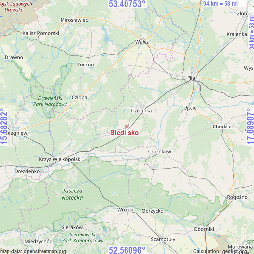
Siedlisko GPS coordinates[2]
52° 59' 10.752" North, 16° 23' 9.384" East
| Map corner | latitude | longitude |
|---|---|---|
| Upper-left | 53.40753°, | 15.68282° |
| Center: | 52.98632°, | 16.38594° |
| Lower-right: | 52.56096°, | 17.08907° |
| Map W x H: | 94.1×94.1 km | = 58.5×58.5mi |
| max Lat: | 54.83135° ⇑16.6% North |
| Siedlisko: | 52.98632° |
| min Lat: | ⇓83.4% South 49.21328° |
| min Long | Siedlisko | max Long |
| 14.20249° | 16.38594° | 24.03723° |
| W 9.8%⇐ | ⇒90.2% E |
Elevation
Elevation of Siedlisko is 76 m = 249 ft, and this is 115.4 m = 379 ft below average elevation for this country.
| Max E: |
974 m = 3196 ft | 89.9% |
| Avg. | 191.4 m = 628 ft | |
| Siedlisko | 76 m = 249 ft | |
Min E: |
-3 m = -10 ft | 10.1% |
See also: Poland elevation on elevation.city.
Geographical zone
Siedlisko is located in North temperate zone (between Tropic of Cancer and the Arctic Circle). Distance of this North polar circle is 1509.6 km =938 mi to North.| Distance of | km | miles | from Siedlisko |
|---|---|---|---|
| North Pole | 4115.5 | 2557.3 | to North |
| Arctic Circle | 1509.6 | 938 | to North |
| Tropic Cancer | 3285.6 | 2041.6 | to South |
| Equator | 5891.5 | 3660.8 | to South |


Nearby cities:
15 places around Siedlisko: (largest is in red/bold)
• Czarnków
15.2 km =9.4 mi,  128°
128°
• Człopa
21 km =13 mi,  302°
302°
• Drawsko
27.9 km =17.3 mi,  238°
238°
• Krzyż Wielkopolski
27.7 km =17.2 mi, 244°
• Lubasz
17.5 km =10.9 mi,  148°
148°
• Piła
29.8 km =18.5 mi,  52°
52°
• Połajewo
31.2 km =19.4 mi, 131°
• Skrzatusz
27.5 km =17.1 mi,  28°
28°
• Szydłowo
24.7 km =15.3 mi,  37°
37°
• Trzcianka
7.7 km =4.8 mi, 37°
• Tuczno
27.8 km =17.3 mi,  326°
326°
• Ujście
24.3 km =15.1 mi,  72°
72°
• Wałcz
32.9 km =20.4 mi,  9°
9°
• Wieleń
17.6 km =10.9 mi,  234°
234°
• Wronki
30.7 km =19.1 mi,  180°
180°
Sources, notices
• [Note1] Compared only with cities in Poland existing in our database
• [Src1] Map data: © OpenStreetMap contributors (CC-BY-SA)
• [Src2] Other city data from geonames.org with taken over terms of usage.
• [Src3] Geographical zone / Annual Mean Temperature by Robert A. Rohde @ Wikipedia
