Lubasz geodata
Lubasz (Greater Poland) is a seat of a third-order administrative division; located in Poland in Europe/Warsaw (GMT+2) time zone. With population of 2,861 people, there are 1098 cities with bigger population in this country. Compared to other cities in Poland, 81.6% of cities are located further ↓South; 89.4% of cities are located further →East and 88.4% of cities have higher elevation than Lubasz. Note1
Administrative division(s):
- Level 1: Greater Poland
- Level 2: Powiat czarnkowsko-trzcianecki
- Level 3: Lubasz


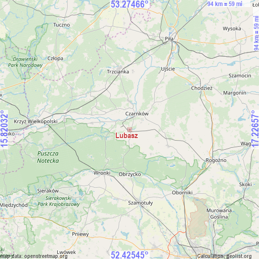
Lubasz GPS coordinates[2]
52° 51' 7.668" North, 16° 31' 24.384" East
| Map corner | latitude | longitude |
|---|---|---|
| Upper-left | 53.27466°, | 15.82032° |
| Center: | 52.85213°, | 16.52344° |
| Lower-right: | 52.42545°, | 17.22657° |
| Map W x H: | 94.4×94.4 km | = 58.7×58.7mi |
| max Lat: | 54.83135° ⇑18.4% North |
| Lubasz: | 52.85213° |
| min Lat: | ⇓81.6% South 49.21328° |
| min Long | Lubasz | max Long |
| 14.20249° | 16.52344° | 24.03723° |
| W 10.6%⇐ | ⇒89.4% E |
Elevation
Elevation of Lubasz is 80 m = 262 ft, and this is 111.4 m = 365 ft below average elevation for this country.
| Max E: |
974 m = 3196 ft | 88.4% |
| Avg. | 191.4 m = 628 ft | |
| Lubasz | 80 m = 262 ft | |
Min E: |
-3 m = -10 ft | 11.6% |
See also: Poland elevation on elevation.city.
Geographical zone
Lubasz is located in North temperate zone (between Tropic of Cancer and the Arctic Circle). Distance of this North polar circle is 1524.6 km =947.3 mi to North.| Distance of | km | miles | from Lubasz |
|---|---|---|---|
| North Pole | 4130.5 | 2566.6 | to North |
| Arctic Circle | 1524.6 | 947.3 | to North |
| Tropic Cancer | 3270.7 | 2032.3 | to South |
| Equator | 5876.6 | 3651.5 | to South |


Nearby cities:
15 places around Lubasz: (largest is in red/bold)
• Budzyń
31.5 km =19.6 mi,  82°
82°
• Chodzież
31 km =19.3 mi,  59°
59°
• Czarnków
6.2 km =3.9 mi,  26°
26°
• Lipnica
31.4 km =19.5 mi,  185°
185°
• Oborniki
30 km =18.6 mi,  139°
139°
• Obrzycko
16.5 km =10.3 mi,  178°
178°
• Ostroróg
25.6 km =15.9 mi, 191°
• Połajewo
15.3 km =9.5 mi,  112°
112°
• Ryczywół
21.1 km =13.1 mi,  101°
101°
• Siedlisko
17.5 km =10.9 mi,  328°
328°
• Szamotuły
26.9 km =16.7 mi,  172°
172°
• Trzcianka
21.4 km =13.3 mi,  347°
347°
• Ujście
26.4 km =16.4 mi, 31°
• Wieleń
24.1 km =15 mi,  281°
281°
• Wronki
18.5 km =11.5 mi,  211°
211°
Sources, notices
• [Note1] Compared only with cities in Poland existing in our database
• [Src1] Map data: © OpenStreetMap contributors (CC-BY-SA)
• [Src2] Other city data from geonames.org with taken over terms of usage.
• [Src3] Geographical zone / Annual Mean Temperature by Robert A. Rohde @ Wikipedia
