Szubin geodata
Szubin (Kujawsko-Pomorskie) is a seat of a third-order administrative division; located in Poland in Europe/Warsaw (GMT+2) time zone. With population of 9,206 people, there are 470 cities with bigger population in this country. Compared to other cities in Poland, 83.7% of cities are located further ↓South; 77.8% of cities are located further →East and 88.4% of cities have higher elevation than Szubin. Note1


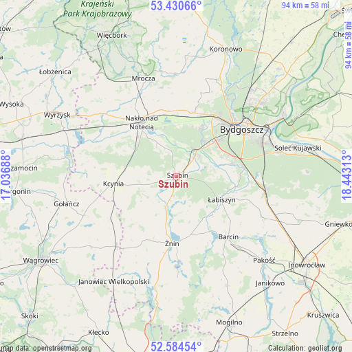
Szubin GPS coordinates[2]
53° 0' 34.812" North, 17° 44' 24" East
| Map corner | latitude | longitude |
|---|---|---|
| Upper-left | 53.43066°, | 17.03688° |
| Center: | 53.00967°, | 17.74° |
| Lower-right: | 52.58454°, | 18.44313° |
| Map W x H: | 94.1×94.1 km | = 58.5×58.5mi |
| max Lat: | 54.83135° ⇑16.3% North |
| Szubin: | 53.00967° |
| min Lat: | ⇓83.7% South 49.21328° |
| min Long | Szubin | max Long |
| 14.20249° | 17.74° | 24.03723° |
| W 22.2%⇐ | ⇒77.8% E |
Elevation
Elevation of Szubin is 80 m = 262 ft, and this is 111.4 m = 365 ft below average elevation for this country.
| Max E: |
974 m = 3196 ft | 88.4% |
| Avg. | 191.4 m = 628 ft | |
| Szubin | 80 m = 262 ft | |
Min E: |
-3 m = -10 ft | 11.6% |
See also: Poland elevation on elevation.city.
Geographical zone
Szubin is located in North temperate zone (between Tropic of Cancer and the Arctic Circle). Distance of this North polar circle is 1507.1 km =936.5 mi to North.| Distance of | km | miles | from Szubin |
|---|---|---|---|
| North Pole | 4112.9 | 2555.6 | to North |
| Arctic Circle | 1507.1 | 936.5 | to North |
| Tropic Cancer | 3288.2 | 2043.2 | to South |
| Equator | 5894.1 | 3662.4 | to South |


Nearby cities:
15 places around Szubin: (largest is in red/bold)
• Barcin
21.1 km =13.1 mi,  139°
139°
• Białe Błota
15.1 km =9.4 mi,  51°
51°
• Brzyskorzystewko
13.4 km =8.3 mi,  193°
193°
• Bydgoszcz
21.9 km =13.6 mi, 54°
• Kcynia
17 km =10.6 mi,  263°
263°
• Kołaczkowo
4 km =2.5 mi, 48°
• Krotoszyn
23.1 km =14.4 mi, 141°
• Królikowo
9.5 km =5.9 mi,  234°
234°
• Nakło nad Notecią
17.4 km =10.8 mi,  327°
327°
• Sarbinowo
18.3 km =11.4 mi,  195°
195°
• Sicienko
22 km =13.7 mi,  10°
10°
• Wapno
21 km =13 mi,  237°
237°
• Łabiszyn
13.6 km =8.5 mi,  118°
118°
• Ślesin
17.5 km =10.9 mi,  351°
351°
• Żnin
17.9 km =11.1 mi,  184°
184°
Sources, notices
• [Note1] Compared only with cities in Poland existing in our database
• [Src1] Map data: © OpenStreetMap contributors (CC-BY-SA)
• [Src2] Other city data from geonames.org with taken over terms of usage.
• [Src3] Geographical zone / Annual Mean Temperature by Robert A. Rohde @ Wikipedia
