Bydgoszcz geodata
Bydgoszcz (Kujawsko-Pomorskie) is a seat of a first-order administrative division; located in Poland in Europe/Warsaw (GMT+2) time zone. With population of 366,452 people, there are 7 cities with bigger population in this country. Compared to other cities in Poland, 85.3% of cities are located further ↓South; 75.1% of cities are located further →East and 95.4% of cities have higher elevation than Bydgoszcz. Note1


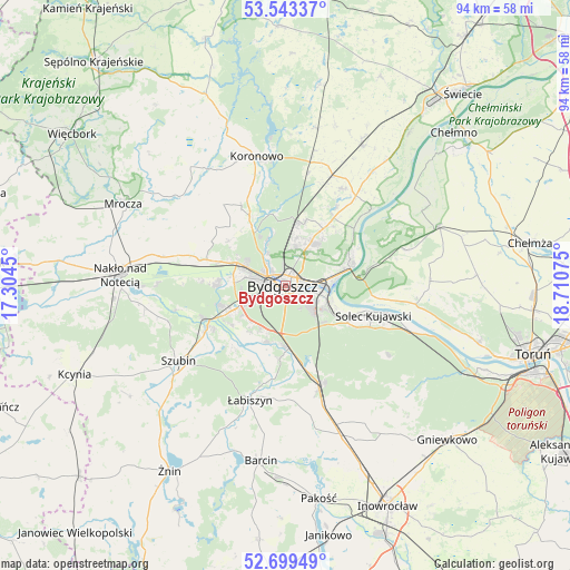
Bydgoszcz GPS coordinates[2]
53° 7' 24.6" North, 18° 0' 27.432" East
| Map corner | latitude | longitude |
|---|---|---|
| Upper-left | 53.54337°, | 17.3045° |
| Center: | 53.1235°, | 18.00762° |
| Lower-right: | 52.69949°, | 18.71075° |
| Map W x H: | 93.8×93.8 km | = 58.3×58.3mi |
| max Lat: | 54.83135° ⇑14.7% North |
| Bydgoszcz: | 53.1235° |
| min Lat: | ⇓85.3% South 49.21328° |
| min Long | Bydgoszcz | max Long |
| 14.20249° | 18.00762° | 24.03723° |
| W 24.9%⇐ | ⇒75.1% E |
Elevation
Elevation of Bydgoszcz is 37 m = 121 ft, and this is 154.4 m = 507 ft below average elevation for this country.
| Max E: |
974 m = 3196 ft | 95.4% |
| Avg. | 191.4 m = 628 ft | |
| Bydgoszcz | 37 m = 121 ft | |
Min E: |
-3 m = -10 ft | 4.6% |
See also: Bydgoszcz elevation on elevation.city.
Geographical zone
Bydgoszcz is located in North temperate zone (between Tropic of Cancer and the Arctic Circle). Distance of this North polar circle is 1494.4 km =928.6 mi to North.| Distance of | km | miles | from Bydgoszcz |
|---|---|---|---|
| North Pole | 4100.3 | 2547.8 | to North |
| Arctic Circle | 1494.4 | 928.6 | to North |
| Tropic Cancer | 3300.9 | 2051.1 | to South |
| Equator | 5906.8 | 3670.3 | to South |


Nearby cities:
15 places around Bydgoszcz: (largest is in red/bold)
• Białe Błota
6.9 km =4.3 mi,  242°
242°
• Dobrcz
18.4 km =11.4 mi,  30°
30°
• Dąbrowa Chełmińska
20.7 km =12.9 mi,  73°
73°
• Fordon
11.2 km =7 mi,  75°
75°
• Koronowo
21.7 km =13.5 mi,  347°
347°
• Kołaczkowo
18 km =11.2 mi, 236°
• Nowa Wieś Wielka
17.8 km =11.1 mi,  161°
161°
• Osielsko
8.5 km =5.3 mi,  36°
36°
• Sicienko
16.4 km =10.2 mi,  302°
302°
• Solec Kujawski
15.2 km =9.4 mi,  106°
106°
• Szubin
21.9 km =13.6 mi,  234°
234°
• Toporzysko
19.2 km =11.9 mi,  97°
97°
• Zławieś Wielka
21.7 km =13.5 mi, 98°
• Łabiszyn
19.9 km =12.4 mi,  197°
197°
• Ślesin
20.9 km =13 mi,  282°
282°
Sources, notices
• [Note1] Compared only with cities in Poland existing in our database
• [Src1] Map data: © OpenStreetMap contributors (CC-BY-SA)
• [Src2] Other city data from geonames.org with taken over terms of usage.
• [Src3] Geographical zone / Annual Mean Temperature by Robert A. Rohde @ Wikipedia
