Białe Błota geodata
Białe Błota (Kujawsko-Pomorskie) is a populated place; located in Poland in Europe/Warsaw (GMT+2) time zone. With population of 5,989 people, there are 607 cities with bigger population in this country. Compared to other cities in Poland, 84.8% of cities are located further ↓South; 76.1% of cities are located further →East and 91.1% of cities have higher elevation than Białe Błota. Note1
Administrative division(s):
- Level 1: Kujawsko-Pomorskie
- Level 2: Powiat bydgoski
- Level 3: Białe Błota


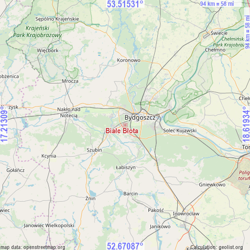
Białe Błota GPS coordinates[2]
53° 5' 42.576" North, 17° 54' 58.356" East
| Map corner | latitude | longitude |
|---|---|---|
| Upper-left | 53.51531°, | 17.21309° |
| Center: | 53.09516°, | 17.91621° |
| Lower-right: | 52.67087°, | 18.61934° |
| Map W x H: | 93.9×93.9 km | = 58.3×58.3mi |
| max Lat: | 54.83135° ⇑15.2% North |
| Białe Błota: | 53.09516° |
| min Lat: | ⇓84.8% South 49.21328° |
| min Long | Białe Błota | max Long |
| 14.20249° | 17.91621° | 24.03723° |
| W 23.9%⇐ | ⇒76.1% E |
Elevation
Elevation of Białe Błota is 70 m = 230 ft, and this is 121.4 m = 398 ft below average elevation for this country.
| Max E: |
974 m = 3196 ft | 91.1% |
| Avg. | 191.4 m = 628 ft | |
| Białe Błota | 70 m = 230 ft | |
Min E: |
-3 m = -10 ft | 8.9% |
See also: Poland elevation on elevation.city.
Geographical zone
Białe Błota is located in North temperate zone (between Tropic of Cancer and the Arctic Circle). Distance of this North polar circle is 1497.5 km =930.5 mi to North.| Distance of | km | miles | from Białe Błota |
|---|---|---|---|
| North Pole | 4103.4 | 2549.7 | to North |
| Arctic Circle | 1497.5 | 930.5 | to North |
| Tropic Cancer | 3297.7 | 2049.1 | to South |
| Equator | 5903.6 | 3668.3 | to South |


Nearby cities:
15 places around Białe Błota: (largest is in red/bold)
• Bydgoszcz
6.9 km =4.3 mi,  62°
62°
• Dobrcz
24.4 km =15.2 mi,  39°
39°
• Fordon
18 km =11.2 mi,  70°
70°
• Koronowo
24.3 km =15.1 mi,  3°
3°
• Kołaczkowo
11.2 km =7 mi,  232°
232°
• Królikowo
24.7 km =15.3 mi, 232°
• Nakło nad Notecią
21.6 km =13.4 mi,  283°
283°
• Nowa Wieś Wielka
18 km =11.2 mi,  139°
139°
• Osielsko
15 km =9.3 mi,  48°
48°
• Sicienko
14.3 km =8.9 mi,  327°
327°
• Solec Kujawski
20.7 km =12.9 mi,  93°
93°
• Szubin
15.1 km =9.4 mi, 231°
• Toporzysko
25.1 km =15.6 mi, 88°
• Łabiszyn
15.9 km =9.9 mi,  179°
179°
• Ślesin
16.2 km =10.1 mi,  298°
298°
Sources, notices
• [Note1] Compared only with cities in Poland existing in our database
• [Src1] Map data: © OpenStreetMap contributors (CC-BY-SA)
• [Src2] Other city data from geonames.org with taken over terms of usage.
• [Src3] Geographical zone / Annual Mean Temperature by Robert A. Rohde @ Wikipedia
