Żnin geodata
Żnin (Kujawsko-Pomorskie) is a seat of a second-order administrative division; located in Poland in Europe/Warsaw (GMT+2) time zone. With population of 14,008 people, there are 354 cities with bigger population in this country. Compared to other cities in Poland, 81.5% of cities are located further ↓South; 78% of cities are located further →East and 87.8% of cities have higher elevation than Żnin. Note1


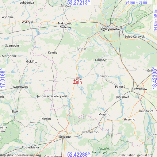
Żnin GPS coordinates[2]
52° 50' 58.488" North, 17° 43' 11.712" East
| Map corner | latitude | longitude |
|---|---|---|
| Upper-left | 53.27213°, | 17.0168° |
| Center: | 52.84958°, | 17.71992° |
| Lower-right: | 52.42288°, | 18.42305° |
| Map W x H: | 94.4×94.4 km | = 58.7×58.7mi |
| max Lat: | 54.83135° ⇑18.5% North |
| Żnin: | 52.84958° |
| min Lat: | ⇓81.5% South 49.21328° |
| min Long | Żnin | max Long |
| 14.20249° | 17.71992° | 24.03723° |
| W 22%⇐ | ⇒78% E |
Elevation
Elevation of Żnin is 82 m = 269 ft, and this is 109.4 m = 359 ft below average elevation for this country.
| Max E: |
974 m = 3196 ft | 87.8% |
| Avg. | 191.4 m = 628 ft | |
| Żnin | 82 m = 269 ft | |
Min E: |
-3 m = -10 ft | 12.2% |
See also: Poland elevation on elevation.city.
Geographical zone
Żnin is located in North temperate zone (between Tropic of Cancer and the Arctic Circle). Distance of this North polar circle is 1524.9 km =947.5 mi to North.| Distance of | km | miles | from Żnin |
|---|---|---|---|
| North Pole | 4130.7 | 2566.7 | to North |
| Arctic Circle | 1524.9 | 947.5 | to North |
| Tropic Cancer | 3270.4 | 2032.1 | to South |
| Equator | 5876.3 | 3651.4 | to South |


Nearby cities:
15 places around Żnin: (largest is in red/bold)
• Barcin
15.3 km =9.5 mi,  83°
83°
• Brzyskorzystewko
5.1 km =3.2 mi,  338°
338°
• Damasławek
14.8 km =9.2 mi,  265°
265°
• Dąbrowa
18.9 km =11.7 mi,  127°
127°
• Gąsawa
9.4 km =5.8 mi,  165°
165°
• Janowiec Wielkopolski
18.7 km =11.6 mi,  236°
236°
• Kcynia
22.2 km =13.8 mi,  315°
315°
• Kołaczkowo
20.9 km =13 mi,  11°
11°
• Krotoszyn
15.9 km =9.9 mi,  90°
90°
• Królikowo
13.8 km =8.6 mi,  332°
332°
• Rogowo
14.7 km =9.1 mi,  198°
198°
• Sarbinowo
3.6 km =2.2 mi, 273°
• Szubin
17.9 km =11.1 mi,  4°
4°
• Wapno
17.7 km =11 mi,  291°
291°
• Łabiszyn
17.6 km =10.9 mi,  49°
49°
Sources, notices
• [Note1] Compared only with cities in Poland existing in our database
• [Src1] Map data: © OpenStreetMap contributors (CC-BY-SA)
• [Src2] Other city data from geonames.org with taken over terms of usage.
• [Src3] Geographical zone / Annual Mean Temperature by Robert A. Rohde @ Wikipedia
