Ślesin geodata
Ślesin (Kujawsko-Pomorskie) is a populated place; located in Poland in Europe/Warsaw (GMT+2) time zone. With population of 1,500 people, there are 1837 cities with bigger population in this country. Compared to other cities in Poland, 85.9% of cities are located further ↓South; 78.3% of cities are located further →East and 81.8% of cities have higher elevation than Ślesin. Note1
Administrative division(s):
- Level 1: Kujawsko-Pomorskie
- Level 2: Powiat nakielski
- Level 3: Nakło nad Notecią


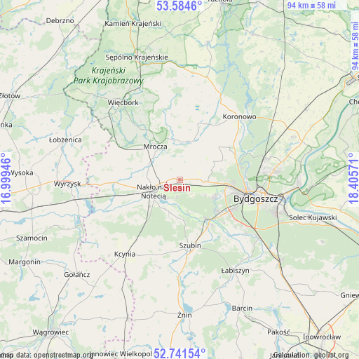
Ślesin GPS coordinates[2]
53° 9' 54.504" North, 17° 42' 9.288" East
| Map corner | latitude | longitude |
|---|---|---|
| Upper-left | 53.5846°, | 16.99946° |
| Center: | 53.16514°, | 17.70258° |
| Lower-right: | 52.74154°, | 18.40571° |
| Map W x H: | 93.7×93.7 km | = 58.2×58.2mi |
| max Lat: | 54.83135° ⇑14.1% North |
| Ślesin: | 53.16514° |
| min Lat: | ⇓85.9% South 49.21328° |
| min Long | Ślesin | max Long |
| 14.20249° | 17.70258° | 24.03723° |
| W 21.7%⇐ | ⇒78.3% E |
Elevation
Elevation of Ślesin is 96 m = 315 ft, and this is 95.4 m = 313 ft below average elevation for this country.
| Max E: |
974 m = 3196 ft | 81.8% |
| Avg. | 191.4 m = 628 ft | |
| Ślesin | 96 m = 315 ft | |
Min E: |
-3 m = -10 ft | 18.2% |
See also: Poland elevation on elevation.city.
Geographical zone
Ślesin is located in North temperate zone (between Tropic of Cancer and the Arctic Circle). Distance of this North polar circle is 1489.8 km =925.7 mi to North.| Distance of | km | miles | from Ślesin |
|---|---|---|---|
| North Pole | 4095.7 | 2544.9 | to North |
| Arctic Circle | 1489.8 | 925.7 | to North |
| Tropic Cancer | 3305.5 | 2053.9 | to South |
| Equator | 5911.4 | 3673.2 | to South |


Nearby cities:
15 places around Ślesin: (largest is in red/bold)
• Białe Błota
16.2 km =10.1 mi,  118°
118°
• Bydgoszcz
20.9 km =13 mi,  102°
102°
• Kcynia
24 km =14.9 mi,  216°
216°
• Koronowo
22.7 km =14.1 mi,  43°
43°
• Kołaczkowo
15.6 km =9.7 mi,  159°
159°
• Królikowo
23.4 km =14.5 mi,  192°
192°
• Mrocza
10.9 km =6.8 mi,  322°
322°
• Nakło nad Notecią
7.2 km =4.5 mi,  249°
249°
• Osielsko
25.5 km =15.8 mi,  85°
85°
• Sadki
16.9 km =10.5 mi,  268°
268°
• Sicienko
7.8 km =4.8 mi,  56°
56°
• Sośno
24.9 km =15.5 mi,  357°
357°
• Szubin
17.5 km =10.9 mi,  171°
171°
• Więcbork
25.3 km =15.7 mi,  326°
326°
• Łabiszyn
27.8 km =17.3 mi,  148°
148°
Sources, notices
• [Note1] Compared only with cities in Poland existing in our database
• [Src1] Map data: © OpenStreetMap contributors (CC-BY-SA)
• [Src2] Other city data from geonames.org with taken over terms of usage.
• [Src3] Geographical zone / Annual Mean Temperature by Robert A. Rohde @ Wikipedia
