Szprotawa geodata
Szprotawa (Lubusz) is a populated place; located in Poland in Europe/Warsaw (GMT+2) time zone. With population of 12,786 people, there are 374 cities with bigger population in this country. Compared to other cities in Poland, 57.3% of cities are located further ↓South; 95.1% of cities are located further →East and 66.1% of cities have higher elevation than Szprotawa. Note1


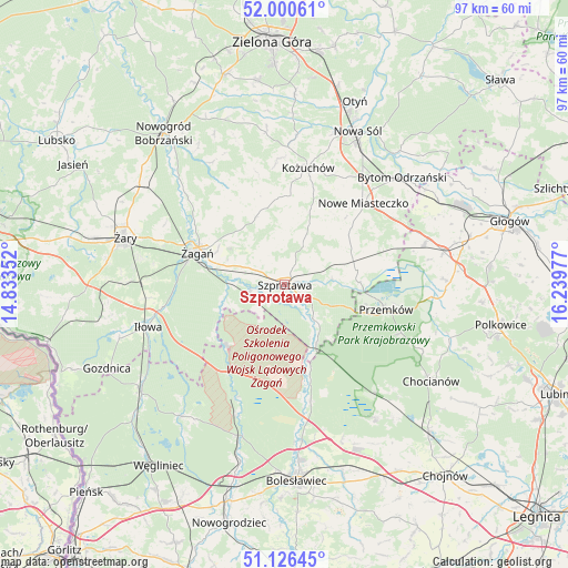
Szprotawa GPS coordinates[2]
51° 33' 56.268" North, 15° 32' 11.904" East
| Map corner | latitude | longitude |
|---|---|---|
| Upper-left | 52.00061°, | 14.83352° |
| Center: | 51.56563°, | 15.53664° |
| Lower-right: | 51.12645°, | 16.23977° |
| Map W x H: | 97.2×97.2 km | = 60.4×60.4mi |
| max Lat: | 54.83135° ⇑42.7% North |
| Szprotawa: | 51.56563° |
| min Lat: | ⇓57.3% South 49.21328° |
| min Long | Szprotawa | max Long |
| 14.20249° | 15.53664° | 24.03723° |
| W 4.9%⇐ | ⇒95.1% E |
Elevation
Elevation of Szprotawa is 130 m = 427 ft, and this is 61.4 m = 201 ft below average elevation for this country.
| Max E: |
974 m = 3196 ft | 66.1% |
| Avg. | 191.4 m = 628 ft | |
| Szprotawa | 130 m = 427 ft | |
Min E: |
-3 m = -10 ft | 33.9% |
See also: Poland elevation on elevation.city.
Geographical zone
Szprotawa is located in North temperate zone (between Tropic of Cancer and the Arctic Circle). Distance of this North polar circle is 1667.6 km =1036.2 mi to North.| Distance of | km | miles | from Szprotawa |
|---|---|---|---|
| North Pole | 4273.5 | 2655.4 | to North |
| Arctic Circle | 1667.6 | 1036.2 | to North |
| Tropic Cancer | 3127.6 | 1943.4 | to South |
| Equator | 5733.6 | 3562.7 | to South |


Nearby cities:
15 places around Szprotawa: (largest is in red/bold)
• Brzeźnica
19.3 km =12 mi,  329°
329°
• Bytom Odrzański
27 km =16.8 mi,  47°
47°
• Gaworzyce
24.8 km =15.4 mi,  73°
73°
• Gromadka
27.7 km =17.2 mi,  145°
145°
• Iłowa
24.4 km =15.2 mi,  252°
252°
• Kożuchów
20.4 km =12.7 mi,  11°
11°
• Kunice Żarskie
26 km =16.2 mi,  278°
278°
• Kłobuczyn
27.8 km =17.3 mi,  78°
78°
• Małomice
6.1 km =3.8 mi,  259°
259°
• Niegosławice
12.5 km =7.8 mi, 78°
• Nowe Miasteczko
19.4 km =12.1 mi,  44°
44°
• Osiecznica
27.7 km =17.2 mi,  196°
196°
• Przemków
18.4 km =11.4 mi,  104°
104°
• Radwanice
28.4 km =17.6 mi,  88°
88°
• Żagań
16.4 km =10.2 mi,  290°
290°
Sources, notices
• [Note1] Compared only with cities in Poland existing in our database
• [Src1] Map data: © OpenStreetMap contributors (CC-BY-SA)
• [Src2] Other city data from geonames.org with taken over terms of usage.
• [Src3] Geographical zone / Annual Mean Temperature by Robert A. Rohde @ Wikipedia
