Kożuchów geodata
Kożuchów (Lubusz) is a seat of a third-order administrative division; located in Poland in Europe/Warsaw (GMT+2) time zone. With population of 9,679 people, there are 455 cities with bigger population in this country. Compared to other cities in Poland, 61% of cities are located further ↓South; 94.8% of cities are located further →East and 79.3% of cities have higher elevation than Kożuchów. Note1


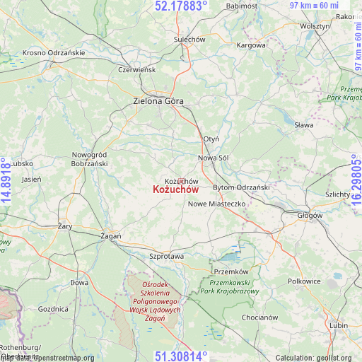
Kożuchów GPS coordinates[2]
51° 44' 44.088" North, 15° 35' 41.712" East
| Map corner | latitude | longitude |
|---|---|---|
| Upper-left | 52.17883°, | 14.8918° |
| Center: | 51.74558°, | 15.59492° |
| Lower-right: | 51.30814°, | 16.29805° |
| Map W x H: | 96.8×96.8 km | = 60.1×60.1mi |
| max Lat: | 54.83135° ⇑39% North |
| Kożuchów: | 51.74558° |
| min Lat: | ⇓61% South 49.21328° |
| min Long | Kożuchów | max Long |
| 14.20249° | 15.59492° | 24.03723° |
| W 5.2%⇐ | ⇒94.8% E |
Elevation
Elevation of Kożuchów is 101 m = 331 ft, and this is 90.4 m = 297 ft below average elevation for this country.
| Max E: |
974 m = 3196 ft | 79.3% |
| Avg. | 191.4 m = 628 ft | |
| Kożuchów | 101 m = 331 ft | |
Min E: |
-3 m = -10 ft | 20.7% |
See also: Poland elevation on elevation.city.
Geographical zone
Kożuchów is located in North temperate zone (between Tropic of Cancer and the Arctic Circle). Distance of this North polar circle is 1647.6 km =1023.8 mi to North.| Distance of | km | miles | from Kożuchów |
|---|---|---|---|
| North Pole | 4253.5 | 2643 | to North |
| Arctic Circle | 1647.6 | 1023.8 | to North |
| Tropic Cancer | 3147.7 | 1955.9 | to South |
| Equator | 5753.6 | 3575.1 | to South |


Nearby cities:
15 places around Kożuchów: (largest is in red/bold)
• Bobrowniki
16.3 km =10.1 mi,  35°
35°
• Brzeźnica
14.3 km =8.9 mi,  255°
255°
• Bytom Odrzański
15.8 km =9.8 mi,  96°
96°
• Kaczeniec
19.6 km =12.2 mi,  296°
296°
• Niegosławice
19.3 km =12 mi,  155°
155°
• Niwiska
16.3 km =10.1 mi, 300°
• Nowa Sól
10.6 km =6.6 mi,  52°
52°
• Nowe Miasteczko
11.2 km =7 mi,  122°
122°
• Ochla
17.1 km =10.6 mi,  330°
330°
• Otyń
13.9 km =8.6 mi, 35°
• Przyborów
13.4 km =8.3 mi,  63°
63°
• Siedlisko
15.3 km =9.5 mi,  80°
80°
• Szprotawa
20.4 km =12.7 mi,  191°
191°
• Zielona Góra
22 km =13.7 mi,  343°
343°
• Świdnica
21.2 km =13.2 mi,  318°
318°
Sources, notices
• [Note1] Compared only with cities in Poland existing in our database
• [Src1] Map data: © OpenStreetMap contributors (CC-BY-SA)
• [Src2] Other city data from geonames.org with taken over terms of usage.
• [Src3] Geographical zone / Annual Mean Temperature by Robert A. Rohde @ Wikipedia
