Gromadka geodata
Gromadka (Lower Silesia) is a seat of a third-order administrative division; located in Poland in Europe/Warsaw (GMT+2) time zone. With population of 2,150 people, there are 1386 cities with bigger population in this country. Compared to other cities in Poland, 54.2% of cities are located further ↓South; 93.8% of cities are located further →East and 59.5% of cities have higher elevation than Gromadka. Note1


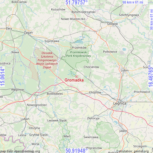
Gromadka GPS coordinates[2]
51° 21' 38.268" North, 15° 45' 52.272" East
| Map corner | latitude | longitude |
|---|---|---|
| Upper-left | 51.79757°, | 15.0614° |
| Center: | 51.36063°, | 15.76452° |
| Lower-right: | 50.91948°, | 16.46765° |
| Map W x H: | 97.6×97.6 km | = 60.6×60.6mi |
| max Lat: | 54.83135° ⇑45.8% North |
| Gromadka: | 51.36063° |
| min Lat: | ⇓54.2% South 49.21328° |
| min Long | Gromadka | max Long |
| 14.20249° | 15.76452° | 24.03723° |
| W 6.2%⇐ | ⇒93.8% E |
Elevation
Elevation of Gromadka is 148 m = 486 ft, and this is 43.4 m = 142 ft below average elevation for this country.
| Max E: |
974 m = 3196 ft | 59.5% |
| Avg. | 191.4 m = 628 ft | |
| Gromadka | 148 m = 486 ft | |
Min E: |
-3 m = -10 ft | 40.5% |
See also: Poland elevation on elevation.city.
Geographical zone
Gromadka is located in North temperate zone (between Tropic of Cancer and the Arctic Circle). Distance of this North polar circle is 1690.4 km =1050.4 mi to North.| Distance of | km | miles | from Gromadka |
|---|---|---|---|
| North Pole | 4296.3 | 2669.6 | to North |
| Arctic Circle | 1690.4 | 1050.4 | to North |
| Tropic Cancer | 3104.8 | 1929.2 | to South |
| Equator | 5710.8 | 3548.5 | to South |


Nearby cities:
15 places around Gromadka: (largest is in red/bold)
• Bolesławiec
17.3 km =10.7 mi,  231°
231°
• Chocianów
11.5 km =7.1 mi,  55°
55°
• Chojnów
15.4 km =9.6 mi,  128°
128°
• Krzywa
9.3 km =5.8 mi,  159°
159°
• Miłkowice
24.4 km =15.2 mi,  118°
118°
• Niegosławice
25.5 km =15.8 mi,  352°
352°
• Olszanica
17.3 km =10.7 mi,  171°
171°
• Osiecznica
24.2 km =15 mi,  261°
261°
• Pielgrzymka
27.4 km =17 mi, 172°
• Polkowice
26.6 km =16.5 mi,  53°
53°
• Przemków
18.4 km =11.4 mi,  6°
6°
• Radwanice
26.6 km =16.5 mi,  28°
28°
• Warta Bolesławiecka
15.9 km =9.9 mi,  205°
205°
• Zagrodno
20.1 km =12.5 mi, 159°
• Łaziska
17.3 km =10.7 mi,  218°
218°
Sources, notices
• [Note1] Compared only with cities in Poland existing in our database
• [Src1] Map data: © OpenStreetMap contributors (CC-BY-SA)
• [Src2] Other city data from geonames.org with taken over terms of usage.
• [Src3] Geographical zone / Annual Mean Temperature by Robert A. Rohde @ Wikipedia
