Kłobuczyn geodata
Kłobuczyn (Lower Silesia) is a populated place; located in Poland in Europe/Warsaw (GMT+2) time zone. With population of 528 people, there are 3461 cities with bigger population in this country. Compared to other cities in Poland, 58.3% of cities are located further ↓South; 92.8% of cities are located further →East and 61.1% of cities have higher elevation than Kłobuczyn. Note1


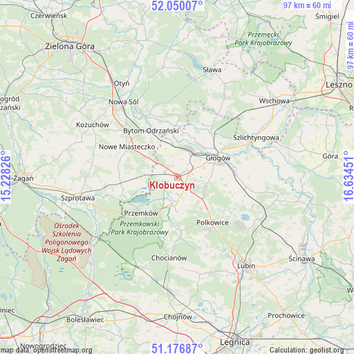
Kłobuczyn GPS coordinates[2]
51° 36' 56.052" North, 15° 55' 52.968" East
| Map corner | latitude | longitude |
|---|---|---|
| Upper-left | 52.05007°, | 15.22826° |
| Center: | 51.61557°, | 15.93138° |
| Lower-right: | 51.17687°, | 16.63451° |
| Map W x H: | 97.1×97.1 km | = 60.3×60.3mi |
| max Lat: | 54.83135° ⇑41.7% North |
| Kłobuczyn: | 51.61557° |
| min Lat: | ⇓58.3% South 49.21328° |
| min Long | Kłobuczyn | max Long |
| 14.20249° | 15.93138° | 24.03723° |
| W 7.2%⇐ | ⇒92.8% E |
Elevation
Elevation of Kłobuczyn is 144 m = 472 ft, and this is 47.4 m = 156 ft below average elevation for this country.
| Max E: |
974 m = 3196 ft | 61.1% |
| Avg. | 191.4 m = 628 ft | |
| Kłobuczyn | 144 m = 472 ft | |
Min E: |
-3 m = -10 ft | 38.9% |
See also: Poland elevation on elevation.city.
Geographical zone
Kłobuczyn is located in North temperate zone (between Tropic of Cancer and the Arctic Circle). Distance of this North polar circle is 1662.1 km =1032.8 mi to North.| Distance of | km | miles | from Kłobuczyn |
|---|---|---|---|
| North Pole | 4267.9 | 2651.9 | to North |
| Arctic Circle | 1662.1 | 1032.8 | to North |
| Tropic Cancer | 3133.2 | 1946.9 | to South |
| Equator | 5739.1 | 3566.1 | to South |


Nearby cities:
15 places around Kłobuczyn: (largest is in red/bold)
• Bielawy
17.1 km =10.6 mi,  1°
1°
• Bytom Odrzański
14.8 km =9.2 mi,  329°
329°
• Chocianów
22 km =13.7 mi,  185°
185°
• Gaworzyce
3.7 km =2.3 mi,  291°
291°
• Grębocice
16.4 km =10.2 mi,  96°
96°
• Głogów
11.8 km =7.3 mi,  63°
63°
• Jerzmanowa
8.1 km =5 mi,  105°
105°
• Kotla
16.1 km =10 mi,  26°
26°
• Niegosławice
15.4 km =9.6 mi,  258°
258°
• Nowe Miasteczko
16.1 km =10 mi,  301°
301°
• Polkowice
15.8 km =9.8 mi,  141°
141°
• Przemków
13.8 km =8.6 mi,  223°
223°
• Radwanice
5.1 km =3.2 mi,  166°
166°
• Siedlisko
18.8 km =11.7 mi, 334°
• Żukowice
7.3 km =4.5 mi, 29°
Sources, notices
• [Note1] Compared only with cities in Poland existing in our database
• [Src1] Map data: © OpenStreetMap contributors (CC-BY-SA)
• [Src2] Other city data from geonames.org with taken over terms of usage.
• [Src3] Geographical zone / Annual Mean Temperature by Robert A. Rohde @ Wikipedia
