Brzeźnica geodata
Brzeźnica (Lubusz) is a populated place; located in Poland in Europe/Warsaw (GMT+2) time zone. With population of 874 people, there are 2719 cities with bigger population in this country. Compared to other cities in Poland, 60.4% of cities are located further ↓South; 96% of cities are located further →East and 75.8% of cities have higher elevation than Brzeźnica. Note1


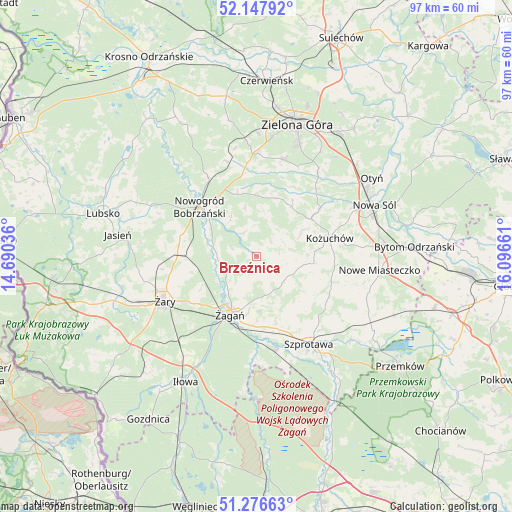
Brzeźnica GPS coordinates[2]
51° 42' 51.732" North, 15° 23' 36.528" East
| Map corner | latitude | longitude |
|---|---|---|
| Upper-left | 52.14792°, | 14.69036° |
| Center: | 51.71437°, | 15.39348° |
| Lower-right: | 51.27663°, | 16.09661° |
| Map W x H: | 96.9×96.9 km | = 60.2×60.2mi |
| max Lat: | 54.83135° ⇑39.6% North |
| Brzeźnica: | 51.71437° |
| min Lat: | ⇓60.4% South 49.21328° |
| min Long | Brzeźnica | max Long |
| 14.20249° | 15.39348° | 24.03723° |
| W 4%⇐ | ⇒96% E |
Elevation
Elevation of Brzeźnica is 109 m = 358 ft, and this is 82.4 m = 270 ft below average elevation for this country.
| Max E: |
974 m = 3196 ft | 75.8% |
| Avg. | 191.4 m = 628 ft | |
| Brzeźnica | 109 m = 358 ft | |
Min E: |
-3 m = -10 ft | 24.2% |
See also: Poland elevation on elevation.city.
Geographical zone
Brzeźnica is located in North temperate zone (between Tropic of Cancer and the Arctic Circle). Distance of this North polar circle is 1651.1 km =1025.9 mi to North.| Distance of | km | miles | from Brzeźnica |
|---|---|---|---|
| North Pole | 4257 | 2645.2 | to North |
| Arctic Circle | 1651.1 | 1025.9 | to North |
| Tropic Cancer | 3144.2 | 1953.7 | to South |
| Equator | 5750.1 | 3572.9 | to South |


Nearby cities:
15 places around Brzeźnica: (largest is in red/bold)
• Kaczeniec
12.9 km =8 mi,  343°
343°
• Kożuchów
14.3 km =8.9 mi,  75°
75°
• Kunice Żarskie
20.3 km =12.6 mi,  230°
230°
• Małomice
18 km =11.2 mi,  167°
167°
• Niwiska
11.8 km =7.3 mi,  359°
359°
• Nowa Sól
24.4 km =15.2 mi,  66°
66°
• Nowe Miasteczko
23.5 km =14.6 mi,  96°
96°
• Nowogród Bobrzański
14.4 km =8.9 mi,  310°
310°
• Ochla
19.1 km =11.9 mi,  16°
16°
• Sieniawa Żarska
24.4 km =15.2 mi,  250°
250°
• Szprotawa
19.3 km =12 mi,  149°
149°
• Zielona Góra
25.8 km =16 mi, 17°
• Świdnica
19.3 km =12 mi, 359°
• Żagań
12 km =7.5 mi,  206°
206°
• Żary
19.4 km =12.1 mi, 245°
Sources, notices
• [Note1] Compared only with cities in Poland existing in our database
• [Src1] Map data: © OpenStreetMap contributors (CC-BY-SA)
• [Src2] Other city data from geonames.org with taken over terms of usage.
• [Src3] Geographical zone / Annual Mean Temperature by Robert A. Rohde @ Wikipedia
