Czersk geodata
Czersk (Pomerania) is a populated place; located in Poland in Europe/Warsaw (GMT+2) time zone. With population of 9,390 people, there are 464 cities with bigger population in this country. Compared to other cities in Poland, 92.2% of cities are located further ↓South; 75.5% of cities are located further →East and 66.1% of cities have higher elevation than Czersk. Note1


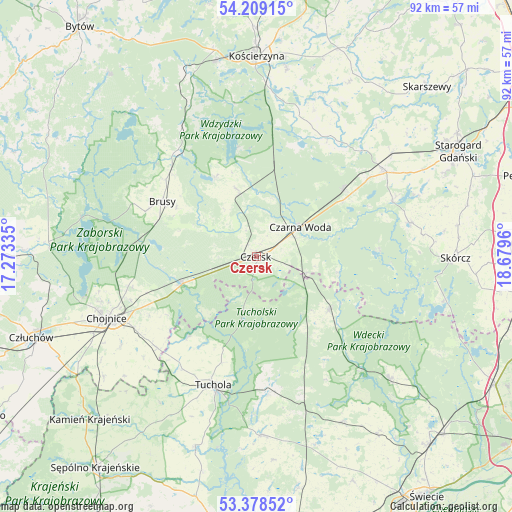
Czersk GPS coordinates[2]
53° 47' 45.204" North, 17° 58' 35.292" East
| Map corner | latitude | longitude |
|---|---|---|
| Upper-left | 54.20915°, | 17.27335° |
| Center: | 53.79589°, | 17.97647° |
| Lower-right: | 53.37852°, | 18.6796° |
| Map W x H: | 92.4×92.4 km | = 57.4×57.4mi |
| max Lat: | 54.83135° ⇑7.8% North |
| Czersk: | 53.79589° |
| min Lat: | ⇓92.2% South 49.21328° |
| min Long | Czersk | max Long |
| 14.20249° | 17.97647° | 24.03723° |
| W 24.5%⇐ | ⇒75.5% E |
Elevation
Elevation of Czersk is 130 m = 427 ft, and this is 61.4 m = 201 ft below average elevation for this country.
| Max E: |
974 m = 3196 ft | 66.1% |
| Avg. | 191.4 m = 628 ft | |
| Czersk | 130 m = 427 ft | |
Min E: |
-3 m = -10 ft | 33.9% |
See also: Poland elevation on elevation.city.
Geographical zone
Czersk is located in North temperate zone (between Tropic of Cancer and the Arctic Circle). Distance of this North polar circle is 1419.6 km =882.1 mi to North.| Distance of | km | miles | from Czersk |
|---|---|---|---|
| North Pole | 4025.5 | 2501.3 | to North |
| Arctic Circle | 1419.6 | 882.1 | to North |
| Tropic Cancer | 3375.6 | 2097.5 | to South |
| Equator | 5981.5 | 3716.7 | to South |


Nearby cities:
15 places around Czersk: (largest is in red/bold)
• Brusy
19.6 km =12.2 mi,  300°
300°
• Cekcyn
24.9 km =15.5 mi,  174°
174°
• Czarna Woda
9.8 km =6.1 mi,  56°
56°
• Dziemiany
27.1 km =16.8 mi,  329°
329°
• Kaliska
20 km =12.4 mi,  52°
52°
• Karsin
13 km =8.1 mi,  343°
343°
• Lubichowo
28.4 km =17.6 mi,  77°
77°
• Osieczna
15.1 km =9.4 mi,  100°
100°
• Ostrowite
27.2 km =16.9 mi,  228°
228°
• Raciąż
19.4 km =12.1 mi,  219°
219°
• Stara Kiszewa
25 km =15.5 mi,  30°
30°
• Szlachta
9.5 km =5.9 mi,  108°
108°
• Tuchola
24.4 km =15.2 mi,  198°
198°
• Zblewo
27.4 km =17 mi, 55°
• Śliwice
16.2 km =10.1 mi,  126°
126°
Sources, notices
• [Note1] Compared only with cities in Poland existing in our database
• [Src1] Map data: © OpenStreetMap contributors (CC-BY-SA)
• [Src2] Other city data from geonames.org with taken over terms of usage.
• [Src3] Geographical zone / Annual Mean Temperature by Robert A. Rohde @ Wikipedia
