Tuchola geodata
Tuchola (Kujawsko-Pomorskie) is a seat of a second-order administrative division; located in Poland in Europe/Warsaw (GMT+2) time zone. With population of 13,686 people, there are 362 cities with bigger population in this country. Compared to other cities in Poland, 90.6% of cities are located further ↓South; 76.7% of cities are located further →East and 75.8% of cities have higher elevation than Tuchola. Note1


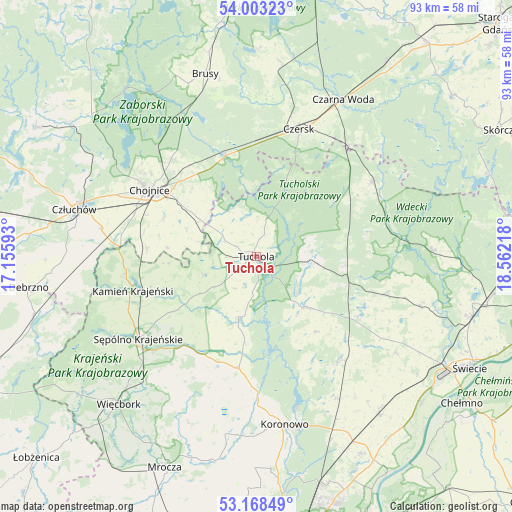
Tuchola GPS coordinates[2]
53° 35' 16.512" North, 17° 51' 32.58" East
| Map corner | latitude | longitude |
|---|---|---|
| Upper-left | 54.00323°, | 17.15593° |
| Center: | 53.58792°, | 17.85905° |
| Lower-right: | 53.16849°, | 18.56218° |
| Map W x H: | 92.8×92.8 km | = 57.7×57.7mi |
| max Lat: | 54.83135° ⇑9.4% North |
| Tuchola: | 53.58792° |
| min Lat: | ⇓90.6% South 49.21328° |
| min Long | Tuchola | max Long |
| 14.20249° | 17.85905° | 24.03723° |
| W 23.3%⇐ | ⇒76.7% E |
Elevation
Elevation of Tuchola is 109 m = 358 ft, and this is 82.4 m = 270 ft below average elevation for this country.
| Max E: |
974 m = 3196 ft | 75.8% |
| Avg. | 191.4 m = 628 ft | |
| Tuchola | 109 m = 358 ft | |
Min E: |
-3 m = -10 ft | 24.2% |
See also: Poland elevation on elevation.city.
Geographical zone
Tuchola is located in North temperate zone (between Tropic of Cancer and the Arctic Circle). Distance of this North polar circle is 1442.8 km =896.5 mi to North.| Distance of | km | miles | from Tuchola |
|---|---|---|---|
| North Pole | 4048.6 | 2515.7 | to North |
| Arctic Circle | 1442.8 | 896.5 | to North |
| Tropic Cancer | 3352.5 | 2083.1 | to South |
| Equator | 5958.4 | 3702.4 | to South |


Nearby cities:
15 places around Tuchola: (largest is in red/bold)
• Cekcyn
10.2 km =6.3 mi,  99°
99°
• Chojnice
23.2 km =14.4 mi,  301°
301°
• Czersk
24.4 km =15.2 mi,  18°
18°
• Gostycyn
11.3 km =7 mi,  196°
196°
• Kamienica
12.5 km =7.8 mi,  194°
194°
• Kamień Krajeński
23.2 km =14.4 mi,  254°
254°
• Kęsowo
10 km =6.2 mi, 251°
• Lniano
24.3 km =15.1 mi,  105°
105°
• Lubiewo
17.7 km =11 mi,  140°
140°
• Ostrowite
13.6 km =8.5 mi,  291°
291°
• Raciąż
9.5 km =5.9 mi,  329°
329°
• Sośno
24.8 km =15.4 mi,  207°
207°
• Szlachta
26.1 km =16.2 mi,  39°
39°
• Śliwice
24.7 km =15.3 mi,  57°
57°
• Świekatowo
24.5 km =15.2 mi, 140°
Sources, notices
• [Note1] Compared only with cities in Poland existing in our database
• [Src1] Map data: © OpenStreetMap contributors (CC-BY-SA)
• [Src2] Other city data from geonames.org with taken over terms of usage.
• [Src3] Geographical zone / Annual Mean Temperature by Robert A. Rohde @ Wikipedia
