Poniec geodata
Poniec (Greater Poland) is a seat of a third-order administrative division; located in Poland in Europe/Warsaw (GMT+2) time zone. With population of 2,849 people, there are 1102 cities with bigger population in this country. Compared to other cities in Poland, 61.3% of cities are located further ↓South; 87.3% of cities are located further →East and 85.2% of cities have higher elevation than Poniec. Note1


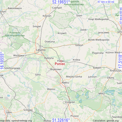
Poniec GPS coordinates[2]
51° 45' 48.348" North, 16° 48' 31.212" East
| Map corner | latitude | longitude |
|---|---|---|
| Upper-left | 52.19651°, | 16.10555° |
| Center: | 51.76343°, | 16.80867° |
| Lower-right: | 51.32616°, | 17.5118° |
| Map W x H: | 96.8×96.8 km | = 60.1×60.1mi |
| max Lat: | 54.83135° ⇑38.7% North |
| Poniec: | 51.76343° |
| min Lat: | ⇓61.3% South 49.21328° |
| min Long | Poniec | max Long |
| 14.20249° | 16.80867° | 24.03723° |
| W 12.7%⇐ | ⇒87.3% E |
Elevation
Elevation of Poniec is 89 m = 292 ft, and this is 102.4 m = 336 ft below average elevation for this country.
| Max E: |
974 m = 3196 ft | 85.2% |
| Avg. | 191.4 m = 628 ft | |
| Poniec | 89 m = 292 ft | |
Min E: |
-3 m = -10 ft | 14.8% |
See also: Poland elevation on elevation.city.
Geographical zone
Poniec is located in North temperate zone (between Tropic of Cancer and the Arctic Circle). Distance of this North polar circle is 1645.6 km =1022.5 mi to North.| Distance of | km | miles | from Poniec |
|---|---|---|---|
| North Pole | 4251.5 | 2641.8 | to North |
| Arctic Circle | 1645.6 | 1022.5 | to North |
| Tropic Cancer | 3149.6 | 1957.1 | to South |
| Equator | 5755.6 | 3576.4 | to South |


Nearby cities:
15 places around Poniec: (largest is in red/bold)
• Bojanowo
7.5 km =4.7 mi,  213°
213°
• Chróścina
18.6 km =11.6 mi,  263°
263°
• Golina Wielka
7.2 km =4.5 mi,  193°
193°
• Gostyń
19.3 km =12 mi,  46°
46°
• Konary
20 km =12.4 mi,  126°
126°
• Krobia
12 km =7.5 mi,  84°
84°
• Krzemieniewo
10.8 km =6.7 mi,  9°
9°
• Leszno
18.2 km =11.3 mi,  298°
298°
• Miejska Górka
15.8 km =9.8 mi,  139°
139°
• Osieczna
18 km =11.2 mi,  330°
330°
• Rawicz
17.5 km =10.9 mi,  168°
168°
• Rydzyna
10 km =6.2 mi,  284°
284°
• Sułkowice
16.2 km =10.1 mi, 79°
• Szymanowo
18.6 km =11.6 mi,  161°
161°
• Słupia Kapitulna
20.1 km =12.5 mi,  149°
149°
Sources, notices
• [Note1] Compared only with cities in Poland existing in our database
• [Src1] Map data: © OpenStreetMap contributors (CC-BY-SA)
• [Src2] Other city data from geonames.org with taken over terms of usage.
• [Src3] Geographical zone / Annual Mean Temperature by Robert A. Rohde @ Wikipedia
