Trzebunia geodata
Trzebunia (Lesser Poland) is a populated place; located in Poland in Europe/Warsaw (GMT+2) time zone. With population of 2,059 people, there are 1447 cities with bigger population in this country. Compared to other cities in Poland, 92.1% of cities are located further ↑North; 55.9% of cities are located further ←West and 94.6% of cities have lower elevation than Trzebunia. Note1


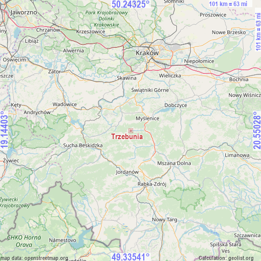
Trzebunia GPS coordinates[2]
49° 47' 29.256" North, 19° 50' 49.74" East
| Map corner | latitude | longitude |
|---|---|---|
| Upper-left | 50.24325°, | 19.14403° |
| Center: | 49.79146°, | 19.84715° |
| Lower-right: | 49.33541°, | 20.55028° |
| Map W x H: | 100.9×100.9 km | = 62.7×62.7mi |
| max Lat: | 54.83135° ⇑92.1% North |
| Trzebunia: | 49.79146° |
| min Lat: | ⇓7.9% South 49.21328° |
| min Long | Trzebunia | max Long |
| 14.20249° | 19.84715° | 24.03723° |
| W 55.9%⇐ | ⇒44.1% E |
Elevation
Elevation of Trzebunia is 406 m = 1332 ft, and this is 214.6 m = 704 ft above average elevation for this country.
| Max E: |
974 m = 3196 ft | 5.4% |
| Trzebunia | 406 m 1332 ft | |
| Avg. | 191.4 m = 628 ft | |
Min E: |
-3 m = -10 ft | 94.6% |
See also: Poland elevation on elevation.city.
Geographical zone
Trzebunia is located in North temperate zone (between Tropic of Cancer and the Arctic Circle). Distance of this North polar circle is 1864.9 km =1158.8 mi to North.| Distance of | km | miles | from Trzebunia |
|---|---|---|---|
| North Pole | 4470.8 | 2778 | to North |
| Arctic Circle | 1864.9 | 1158.8 | to North |
| Tropic Cancer | 2930.4 | 1820.9 | to South |
| Equator | 5536.3 | 3440.1 | to South |


Nearby cities:
15 places around Trzebunia: (largest is in red/bold)
• Baczyn
9.1 km =5.7 mi,  270°
270°
• Bieńkówka
5.7 km =3.5 mi,  252°
252°
• Bęczarka
9.7 km =6 mi,  8°
8°
• Harbutowice
5.3 km =3.3 mi,  295°
295°
• Jasienica
3.5 km =2.2 mi,  353°
353°
• Jastrzębia
8.9 km =5.5 mi,  313°
313°
• Jawornik
7.9 km =4.9 mi,  24°
24°
• Krzczonów
7.8 km =4.8 mi,  139°
139°
• Myślenice
8.1 km =5 mi,  54°
54°
• Palcza
7.6 km =4.7 mi,  281°
281°
• Rudnik
6.8 km =4.2 mi,  0°
0°
• Skomielna Czarna
7.2 km =4.5 mi,  186°
186°
• Stróża
5.5 km =3.4 mi,  84°
84°
• Sułkowice
6.4 km =4 mi,  328°
328°
• Tokarnia
7.4 km =4.6 mi,  166°
166°
Sources, notices
• [Note1] Compared only with cities in Poland existing in our database
• [Src1] Map data: © OpenStreetMap contributors (CC-BY-SA)
• [Src2] Other city data from geonames.org with taken over terms of usage.
• [Src3] Geographical zone / Annual Mean Temperature by Robert A. Rohde @ Wikipedia
