Jawornik geodata
Jawornik (Lesser Poland) is a populated place; located in Poland in Europe/Warsaw (GMT+2) time zone. With population of 2,822 people, there are 1112 cities with bigger population in this country. Compared to other cities in Poland, 89.7% of cities are located further ↑North; 56.8% of cities are located further ←West and 88.1% of cities have lower elevation than Jawornik. Note1


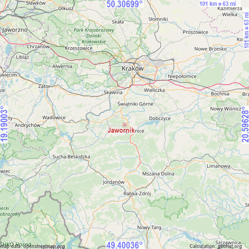
Jawornik GPS coordinates[2]
49° 51' 20.88" North, 19° 53' 35.34" East
| Map corner | latitude | longitude |
|---|---|---|
| Upper-left | 50.30699°, | 19.19003° |
| Center: | 49.8558°, | 19.89315° |
| Lower-right: | 49.40036°, | 20.59628° |
| Map W x H: | 100.8×100.8 km | = 62.6×62.6mi |
| max Lat: | 54.83135° ⇑89.7% North |
| Jawornik: | 49.8558° |
| min Lat: | ⇓10.3% South 49.21328° |
| min Long | Jawornik | max Long |
| 14.20249° | 19.89315° | 24.03723° |
| W 56.8%⇐ | ⇒43.2% E |
Elevation
Elevation of Jawornik is 309 m = 1014 ft, and this is 117.6 m = 386 ft above average elevation for this country.
| Max E: |
974 m = 3196 ft | 11.9% |
| Jawornik | 309 m 1014 ft | |
| Avg. | 191.4 m = 628 ft | |
Min E: |
-3 m = -10 ft | 88.1% |
See also: Poland elevation on elevation.city.
Geographical zone
Jawornik is located in North temperate zone (between Tropic of Cancer and the Arctic Circle). Distance of this North polar circle is 1857.7 km =1154.3 mi to North.| Distance of | km | miles | from Jawornik |
|---|---|---|---|
| North Pole | 4463.6 | 2773.6 | to North |
| Arctic Circle | 1857.7 | 1154.3 | to North |
| Tropic Cancer | 2937.5 | 1825.3 | to South |
| Equator | 5543.4 | 3444.5 | to South |


Nearby cities:
15 places around Jawornik: (largest is in red/bold)
• Biertowice
7.4 km =4.6 mi,  284°
284°
• Borzęta
6.2 km =3.9 mi,  83°
83°
• Bęczarka
3.1 km =1.9 mi,  322°
322°
• Głogoczów
4.5 km =2.8 mi,  342°
342°
• Jasienica
5.2 km =3.2 mi,  225°
225°
• Krzyszkowice
3.7 km =2.3 mi,  34°
34°
• Krzywaczka
6.1 km =3.8 mi,  313°
313°
• Myślenice
4.1 km =2.5 mi,  127°
127°
• Osieczany
6.5 km =4 mi,  103°
103°
• Polanka
3.3 km =2.1 mi, 78°
• Rudnik
3.3 km =2.1 mi,  263°
263°
• Siepraw
8 km =5 mi,  35°
35°
• Stróża
7 km =4.3 mi,  161°
161°
• Sułkowice
6.8 km =4.2 mi, 255°
• Trzebunia
7.9 km =4.9 mi,  204°
204°
Sources, notices
• [Note1] Compared only with cities in Poland existing in our database
• [Src1] Map data: © OpenStreetMap contributors (CC-BY-SA)
• [Src2] Other city data from geonames.org with taken over terms of usage.
• [Src3] Geographical zone / Annual Mean Temperature by Robert A. Rohde @ Wikipedia
