Kuków geodata
Kuków (Lesser Poland) is a populated place; located in Poland in Europe/Warsaw (GMT+2) time zone. With population of 1,319 people, there are 2039 cities with bigger population in this country. Compared to other cities in Poland, 93.5% of cities are located further ↑North; 51.2% of cities are located further →East and 95.1% of cities have lower elevation than Kuków. Note1


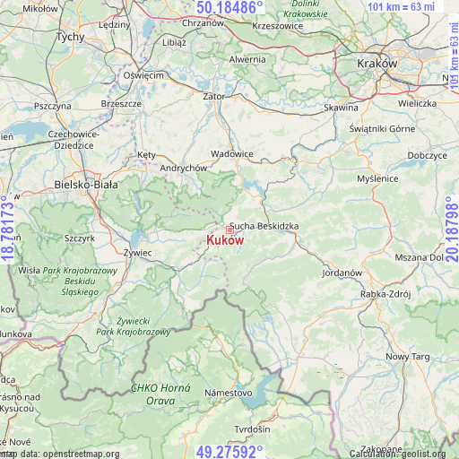
Kuków GPS coordinates[2]
49° 43' 57.072" North, 19° 29' 5.46" East
| Map corner | latitude | longitude |
|---|---|---|
| Upper-left | 50.18486°, | 18.78173° |
| Center: | 49.73252°, | 19.48485° |
| Lower-right: | 49.27592°, | 20.18798° |
| Map W x H: | 101.1×101.1 km | = 62.8×62.8mi |
| max Lat: | 54.83135° ⇑93.5% North |
| Kuków: | 49.73252° |
| min Lat: | ⇓6.5% South 49.21328° |
| min Long | Kuków | max Long |
| 14.20249° | 19.48485° | 24.03723° |
| W 48.8%⇐ | ⇒51.2% E |
Elevation
Elevation of Kuków is 419 m = 1375 ft, and this is 227.6 m = 747 ft above average elevation for this country.
| Max E: |
974 m = 3196 ft | 4.9% |
| Kuków | 419 m 1375 ft | |
| Avg. | 191.4 m = 628 ft | |
Min E: |
-3 m = -10 ft | 95.1% |
See also: Poland elevation on elevation.city.
Geographical zone
Kuków is located in North temperate zone (between Tropic of Cancer and the Arctic Circle). Distance of this North polar circle is 1871.4 km =1162.8 mi to North.| Distance of | km | miles | from Kuków |
|---|---|---|---|
| North Pole | 4477.3 | 2782.1 | to North |
| Arctic Circle | 1871.4 | 1162.8 | to North |
| Tropic Cancer | 2923.8 | 1816.8 | to South |
| Equator | 5529.7 | 3436 | to South |


Nearby cities:
15 places around Kuków: (largest is in red/bold)
• Grzechynia
11.7 km =7.3 mi,  100°
100°
• Koszarawa
11.5 km =7.1 mi,  211°
211°
• Krzeszów
3 km =1.9 mi,  5°
5°
• Kurów
3.8 km =2.4 mi,  251°
251°
• Lachowice
2 km =1.2 mi,  201°
201°
• Marcówka
11.7 km =7.3 mi,  55°
55°
• Mucharz
9.9 km =6.2 mi,  26°
26°
• Pewel Wielka
10.2 km =6.3 mi,  230°
230°
• Ponikiew
11.3 km =7 mi,  352°
352°
• Rzyki
10.8 km =6.7 mi,  323°
323°
• Stryszawa
3.4 km =2.1 mi,  128°
128°
• Sucha Beskidzka
7.9 km =4.9 mi,  82°
82°
• Zawoja
10.7 km =6.6 mi,  157°
157°
• Zembrzyce
9.6 km =6 mi, 60°
• Ślemień
8.6 km =5.3 mi,  259°
259°
Sources, notices
• [Note1] Compared only with cities in Poland existing in our database
• [Src1] Map data: © OpenStreetMap contributors (CC-BY-SA)
• [Src2] Other city data from geonames.org with taken over terms of usage.
• [Src3] Geographical zone / Annual Mean Temperature by Robert A. Rohde @ Wikipedia
