Pruchna geodata
Pruchna (Silesia) is a populated place; located in Poland in Europe/Warsaw (GMT+2) time zone. With population of 2,446 people, there are 1273 cities with bigger population in this country. Compared to other cities in Poland, 89.2% of cities are located further ↑North; 65.3% of cities are located further →East and 84.7% of cities have lower elevation than Pruchna. Note1


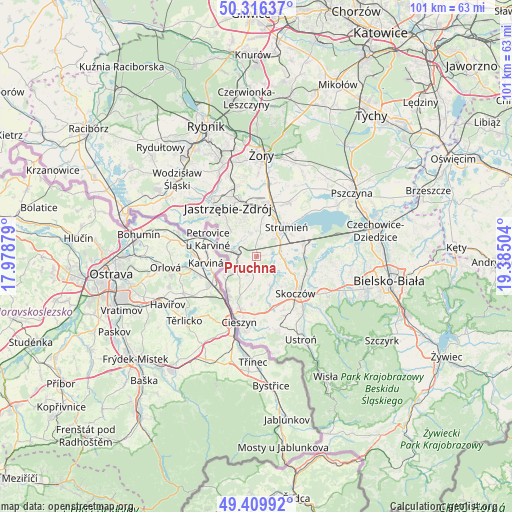
Pruchna GPS coordinates[2]
49° 51' 54.972" North, 18° 40' 54.876" East
| Map corner | latitude | longitude |
|---|---|---|
| Upper-left | 50.31637°, | 17.97879° |
| Center: | 49.86527°, | 18.68191° |
| Lower-right: | 49.40992°, | 19.38504° |
| Map W x H: | 100.8×100.8 km | = 62.6×62.6mi |
| max Lat: | 54.83135° ⇑89.2% North |
| Pruchna: | 49.86527° |
| min Lat: | ⇓10.8% South 49.21328° |
| min Long | Pruchna | max Long |
| 14.20249° | 18.68191° | 24.03723° |
| W 34.7%⇐ | ⇒65.3% E |
Elevation
Elevation of Pruchna is 288 m = 945 ft, and this is 96.6 m = 317 ft above average elevation for this country.
| Max E: |
974 m = 3196 ft | 15.3% |
| Pruchna | 288 m 945 ft | |
| Avg. | 191.4 m = 628 ft | |
Min E: |
-3 m = -10 ft | 84.7% |
See also: Poland elevation on elevation.city.
Geographical zone
Pruchna is located in North temperate zone (between Tropic of Cancer and the Arctic Circle). Distance of this North polar circle is 1856.7 km =1153.7 mi to North.| Distance of | km | miles | from Pruchna |
|---|---|---|---|
| North Pole | 4462.6 | 2772.9 | to North |
| Arctic Circle | 1856.7 | 1153.7 | to North |
| Tropic Cancer | 2938.6 | 1826 | to South |
| Equator | 5544.5 | 3445.2 | to South |


Nearby cities:
15 places around Pruchna: (largest is in red/bold)
• Bąków
3.9 km =2.4 mi,  37°
37°
• Drogomyśl
5.4 km =3.4 mi,  84°
84°
• Dębowiec
6.3 km =3.9 mi,  154°
154°
• Hażlach
6.8 km =4.2 mi,  198°
198°
• Kaczyce
7.7 km =4.8 mi,  237°
237°
• Kostkowice
8 km =5 mi,  169°
169°
• Kończyce Małe
3.8 km =2.4 mi,  258°
258°
• Kończyce Wielkie
4.3 km =2.7 mi,  218°
218°
• Ochaby
6.7 km =4.2 mi,  112°
112°
• Pielgrzymowice
5.1 km =3.2 mi,  332°
332°
• Simoradz
8.2 km =5.1 mi,  136°
136°
• Strumień
8.7 km =5.4 mi, 44°
• Zabłocie
8.3 km =5.2 mi,  59°
59°
• Zbytków
7.2 km =4.5 mi,  26°
26°
• Zebrzydowice
5.3 km =3.3 mi,  285°
285°
Sources, notices
• [Note1] Compared only with cities in Poland existing in our database
• [Src1] Map data: © OpenStreetMap contributors (CC-BY-SA)
• [Src2] Other city data from geonames.org with taken over terms of usage.
• [Src3] Geographical zone / Annual Mean Temperature by Robert A. Rohde @ Wikipedia
