Stolno geodata
Stolno (Kujawsko-Pomorskie) is a populated place; located in Poland in Europe/Warsaw (GMT+2) time zone. With population of 610 people, there are 3248 cities with bigger population in this country. Compared to other cities in Poland, 87.6% of cities are located further ↓South; 68% of cities are located further →East and 85.7% of cities have higher elevation than Stolno. Note1


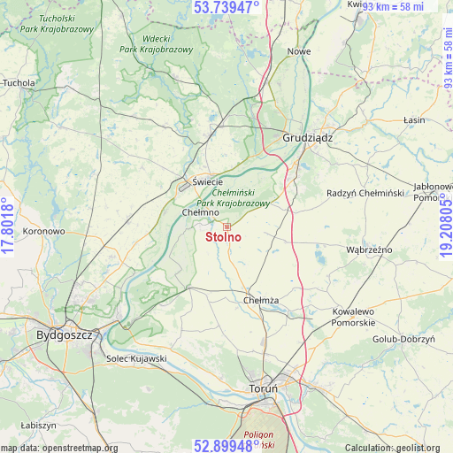
Stolno GPS coordinates[2]
53° 19' 17.544" North, 18° 30' 17.712" East
| Map corner | latitude | longitude |
|---|---|---|
| Upper-left | 53.73947°, | 17.8018° |
| Center: | 53.32154°, | 18.50492° |
| Lower-right: | 52.89948°, | 19.20805° |
| Map W x H: | 93.4×93.4 km | = 58×58mi |
| max Lat: | 54.83135° ⇑12.4% North |
| Stolno: | 53.32154° |
| min Lat: | ⇓87.6% South 49.21328° |
| min Long | Stolno | max Long |
| 14.20249° | 18.50492° | 24.03723° |
| W 32%⇐ | ⇒68% E |
Elevation
Elevation of Stolno is 88 m = 289 ft, and this is 103.4 m = 339 ft below average elevation for this country.
| Max E: |
974 m = 3196 ft | 85.7% |
| Avg. | 191.4 m = 628 ft | |
| Stolno | 88 m = 289 ft | |
Min E: |
-3 m = -10 ft | 14.3% |
See also: Poland elevation on elevation.city.
Geographical zone
Stolno is located in North temperate zone (between Tropic of Cancer and the Arctic Circle). Distance of this North polar circle is 1472.4 km =914.9 mi to North.| Distance of | km | miles | from Stolno |
|---|---|---|---|
| North Pole | 4078.3 | 2534.1 | to North |
| Arctic Circle | 1472.4 | 914.9 | to North |
| Tropic Cancer | 3322.9 | 2064.8 | to South |
| Equator | 5928.8 | 3684 | to South |


Nearby cities:
15 places around Stolno: (largest is in red/bold)
• Bukowiec
21.5 km =13.4 mi,  305°
305°
• Chełmno
6.1 km =3.8 mi,  299°
299°
• Chełmża
16.6 km =10.3 mi,  156°
156°
• Drzycim
24.2 km =15 mi,  327°
327°
• Dąbrowa Chełmińska
21 km =13 mi,  219°
219°
• Grudziądz
24.5 km =15.2 mi,  42°
42°
• Jeżewo
21 km =13 mi,  358°
358°
• Lisewo
12.4 km =7.7 mi,  103°
103°
• Papowo Biskupie
9.1 km =5.7 mi,  153°
153°
• Pruszcz
20.3 km =12.6 mi,  272°
272°
• Płużnica
18.3 km =11.4 mi, 98°
• Skąpe
13.7 km =8.5 mi, 147°
• Unisław
14.5 km =9 mi,  213°
213°
• Łubianka
20.4 km =12.7 mi,  184°
184°
• Świecie
10.5 km =6.5 mi,  338°
338°
Sources, notices
• [Note1] Compared only with cities in Poland existing in our database
• [Src1] Map data: © OpenStreetMap contributors (CC-BY-SA)
• [Src2] Other city data from geonames.org with taken over terms of usage.
• [Src3] Geographical zone / Annual Mean Temperature by Robert A. Rohde @ Wikipedia
