Papowo Biskupie geodata
Papowo Biskupie (Kujawsko-Pomorskie) is a populated place; located in Poland in Europe/Warsaw (GMT+2) time zone. With population of 711 people, there are 3048 cities with bigger population in this country. Compared to other cities in Poland, 86.9% of cities are located further ↓South; 67.2% of cities are located further →East and 84.1% of cities have higher elevation than Papowo Biskupie. Note1
Administrative division(s):
- Level 1: Kujawsko-Pomorskie
- Level 2: Powiat chełmiński
- Level 3: Papowo Biskupie


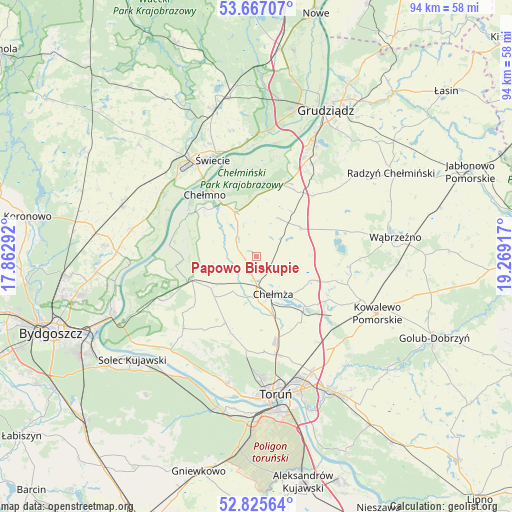
Papowo Biskupie GPS coordinates[2]
53° 14' 54.312" North, 18° 33' 57.744" East
| Map corner | latitude | longitude |
|---|---|---|
| Upper-left | 53.66707°, | 17.86292° |
| Center: | 53.24842°, | 18.56604° |
| Lower-right: | 52.82564°, | 19.26917° |
| Map W x H: | 93.6×93.6 km | = 58.2×58.2mi |
| max Lat: | 54.83135° ⇑13.1% North |
| Papowo Biskupie: | 53.24842° |
| min Lat: | ⇓86.9% South 49.21328° |
| min Long | Papowo Biskupie | max Long |
| 14.20249° | 18.56604° | 24.03723° |
| W 32.8%⇐ | ⇒67.2% E |
Elevation
Elevation of Papowo Biskupie is 91 m = 299 ft, and this is 100.4 m = 329 ft below average elevation for this country.
| Max E: |
974 m = 3196 ft | 84.1% |
| Avg. | 191.4 m = 628 ft | |
| Papowo Biskupie | 91 m = 299 ft | |
Min E: |
-3 m = -10 ft | 15.9% |
See also: Poland elevation on elevation.city.
Geographical zone
Papowo Biskupie is located in North temperate zone (between Tropic of Cancer and the Arctic Circle). Distance of this North polar circle is 1480.5 km =919.9 mi to North.| Distance of | km | miles | from Papowo Biskupie |
|---|---|---|---|
| North Pole | 4086.4 | 2539.2 | to North |
| Arctic Circle | 1480.5 | 919.9 | to North |
| Tropic Cancer | 3314.8 | 2059.7 | to South |
| Equator | 5920.7 | 3679 | to South |


Nearby cities:
15 places around Papowo Biskupie: (largest is in red/bold)
• Chełmno
14.5 km =9 mi,  319°
319°
• Chełmża
7.5 km =4.7 mi,  160°
160°
• Dąbrowa Chełmińska
19.2 km =11.9 mi,  244°
244°
• Kowalewo Pomorskie
24.5 km =15.2 mi,  115°
115°
• Lisewo
9.6 km =6 mi,  56°
56°
• Płużnica
15 km =9.3 mi,  69°
69°
• Skąpe
4.8 km =3 mi,  136°
136°
• Stolno
9.1 km =5.7 mi,  333°
333°
• Toporzysko
24.6 km =15.3 mi,  227°
227°
• Unisław
12.6 km =7.8 mi,  251°
251°
• Wąbrzeźno
25.6 km =15.9 mi,  82°
82°
• Zławieś Wielka
23.2 km =14.4 mi,  222°
222°
• Łubianka
13.5 km =8.4 mi,  204°
204°
• Łysomice
18.4 km =11.4 mi,  168°
168°
• Świecie
19.6 km =12.2 mi,  336°
336°
Sources, notices
• [Note1] Compared only with cities in Poland existing in our database
• [Src1] Map data: © OpenStreetMap contributors (CC-BY-SA)
• [Src2] Other city data from geonames.org with taken over terms of usage.
• [Src3] Geographical zone / Annual Mean Temperature by Robert A. Rohde @ Wikipedia
