Unisław geodata
Unisław (Kujawsko-Pomorskie) is a populated place; located in Poland in Europe/Warsaw (GMT+2) time zone. With population of 3,490 people, there are 916 cities with bigger population in this country. Compared to other cities in Poland, 86.6% of cities are located further ↓South; 70.1% of cities are located further →East and 85.2% of cities have higher elevation than Unisław. Note1


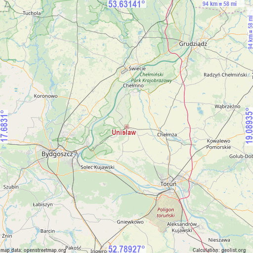
Unisław GPS coordinates[2]
53° 12' 44.676" North, 18° 23' 10.392" East
| Map corner | latitude | longitude |
|---|---|---|
| Upper-left | 53.63141°, | 17.6831° |
| Center: | 53.21241°, | 18.38622° |
| Lower-right: | 52.78927°, | 19.08935° |
| Map W x H: | 93.6×93.6 km | = 58.2×58.2mi |
| max Lat: | 54.83135° ⇑13.4% North |
| Unisław: | 53.21241° |
| min Lat: | ⇓86.6% South 49.21328° |
| min Long | Unisław | max Long |
| 14.20249° | 18.38622° | 24.03723° |
| W 29.9%⇐ | ⇒70.1% E |
Elevation
Elevation of Unisław is 89 m = 292 ft, and this is 102.4 m = 336 ft below average elevation for this country.
| Max E: |
974 m = 3196 ft | 85.2% |
| Avg. | 191.4 m = 628 ft | |
| Unisław | 89 m = 292 ft | |
Min E: |
-3 m = -10 ft | 14.8% |
See also: Poland elevation on elevation.city.
Geographical zone
Unisław is located in North temperate zone (between Tropic of Cancer and the Arctic Circle). Distance of this North polar circle is 1484.5 km =922.4 mi to North.| Distance of | km | miles | from Unisław |
|---|---|---|---|
| North Pole | 4090.4 | 2541.7 | to North |
| Arctic Circle | 1484.5 | 922.4 | to North |
| Tropic Cancer | 3310.7 | 2057.2 | to South |
| Equator | 5916.7 | 3676.5 | to South |


Nearby cities:
15 places around Unisław: (largest is in red/bold)
• Chełmno
15.4 km =9.6 mi,  9°
9°
• Chełmża
14.9 km =9.3 mi,  101°
101°
• Dobrcz
16.9 km =10.5 mi,  290°
290°
• Dąbrowa Chełmińska
6.8 km =4.2 mi,  232°
232°
• Fordon
16.1 km =10 mi,  243°
243°
• Osielsko
20.3 km =12.6 mi,  261°
261°
• Papowo Biskupie
12.6 km =7.8 mi,  71°
71°
• Pruszcz
18.1 km =11.2 mi,  316°
316°
• Skąpe
15.3 km =9.5 mi,  88°
88°
• Solec Kujawski
17.9 km =11.1 mi,  216°
216°
• Stolno
14.5 km =9 mi,  33°
33°
• Toporzysko
14 km =8.7 mi,  206°
206°
• Zławieś Wielka
13.5 km =8.4 mi,  196°
196°
• Łubianka
10.4 km =6.5 mi,  142°
142°
• Łysomice
21 km =13 mi,  131°
131°
Sources, notices
• [Note1] Compared only with cities in Poland existing in our database
• [Src1] Map data: © OpenStreetMap contributors (CC-BY-SA)
• [Src2] Other city data from geonames.org with taken over terms of usage.
• [Src3] Geographical zone / Annual Mean Temperature by Robert A. Rohde @ Wikipedia
