Płużnica geodata
Płużnica (Kujawsko-Pomorskie) is a seat of a third-order administrative division; located in Poland in Europe/Warsaw (GMT+2) time zone. With population of 543 people, there are 3425 cities with bigger population in this country. Compared to other cities in Poland, 87.4% of cities are located further ↓South; 63.8% of cities are located further →East and 81.8% of cities have higher elevation than Płużnica. Note1


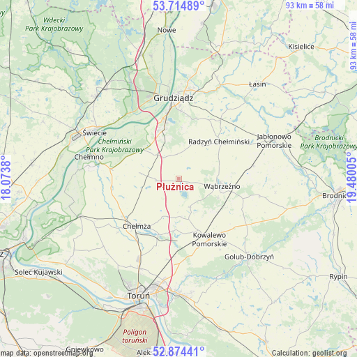
Płużnica GPS coordinates[2]
53° 17' 48.192" North, 18° 46' 36.912" East
| Map corner | latitude | longitude |
|---|---|---|
| Upper-left | 53.71489°, | 18.0738° |
| Center: | 53.29672°, | 18.77692° |
| Lower-right: | 52.87441°, | 19.48005° |
| Map W x H: | 93.5×93.5 km | = 58.1×58.1mi |
| max Lat: | 54.83135° ⇑12.6% North |
| Płużnica: | 53.29672° |
| min Lat: | ⇓87.4% South 49.21328° |
| min Long | Płużnica | max Long |
| 14.20249° | 18.77692° | 24.03723° |
| W 36.2%⇐ | ⇒63.8% E |
Elevation
Elevation of Płużnica is 96 m = 315 ft, and this is 95.4 m = 313 ft below average elevation for this country.
| Max E: |
974 m = 3196 ft | 81.8% |
| Avg. | 191.4 m = 628 ft | |
| Płużnica | 96 m = 315 ft | |
Min E: |
-3 m = -10 ft | 18.2% |
See also: Poland elevation on elevation.city.
Geographical zone
Płużnica is located in North temperate zone (between Tropic of Cancer and the Arctic Circle). Distance of this North polar circle is 1475.1 km =916.6 mi to North.| Distance of | km | miles | from Płużnica |
|---|---|---|---|
| North Pole | 4081 | 2535.8 | to North |
| Arctic Circle | 1475.1 | 916.6 | to North |
| Tropic Cancer | 3320.1 | 2063 | to South |
| Equator | 5926 | 3682.2 | to South |


Nearby cities:
15 places around Płużnica: (largest is in red/bold)
• Chełmno
24.1 km =15 mi,  283°
283°
• Chełmża
16.9 km =10.5 mi,  222°
222°
• Dragasz
23.4 km =14.5 mi,  353°
353°
• Dębowa Łąka
21.7 km =13.5 mi,  102°
102°
• Grudziądz
20.9 km =13 mi,  355°
355°
• Gruta
21.1 km =13.1 mi,  34°
34°
• Kowalewo Pomorskie
17.8 km =11.1 mi,  152°
152°
• Książki
19.8 km =12.3 mi,  79°
79°
• Lisewo
6 km =3.7 mi,  269°
269°
• Ostrowite
22 km =13.7 mi,  141°
141°
• Papowo Biskupie
15 km =9.3 mi,  249°
249°
• Radzyń Chełmiński
14.5 km =9 mi,  47°
47°
• Skąpe
13.9 km =8.6 mi,  230°
230°
• Stolno
18.3 km =11.4 mi, 278°
• Wąbrzeźno
11.5 km =7.1 mi, 99°
Sources, notices
• [Note1] Compared only with cities in Poland existing in our database
• [Src1] Map data: © OpenStreetMap contributors (CC-BY-SA)
• [Src2] Other city data from geonames.org with taken over terms of usage.
• [Src3] Geographical zone / Annual Mean Temperature by Robert A. Rohde @ Wikipedia
