Skarszewy geodata
Skarszewy (Pomerania) is a populated place; located in Poland in Europe/Warsaw (GMT+2) time zone. With population of 6,942 people, there are 542 cities with bigger population in this country. Compared to other cities in Poland, 94.9% of cities are located further ↓South; 69% of cities are located further →East and 74.5% of cities have higher elevation than Skarszewy. Note1


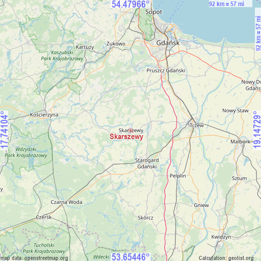
Skarszewy GPS coordinates[2]
54° 4' 8.796" North, 18° 26' 38.976" East
| Map corner | latitude | longitude |
|---|---|---|
| Upper-left | 54.47966°, | 17.74104° |
| Center: | 54.06911°, | 18.44416° |
| Lower-right: | 53.65446°, | 19.14729° |
| Map W x H: | 91.8×91.8 km | = 57×57mi |
| max Lat: | 54.83135° ⇑5.1% North |
| Skarszewy: | 54.06911° |
| min Lat: | ⇓94.9% South 49.21328° |
| min Long | Skarszewy | max Long |
| 14.20249° | 18.44416° | 24.03723° |
| W 31%⇐ | ⇒69% E |
Elevation
Elevation of Skarszewy is 112 m = 367 ft, and this is 79.4 m = 260 ft below average elevation for this country.
| Max E: |
974 m = 3196 ft | 74.5% |
| Avg. | 191.4 m = 628 ft | |
| Skarszewy | 112 m = 367 ft | |
Min E: |
-3 m = -10 ft | 25.5% |
See also: Poland elevation on elevation.city.
Geographical zone
Skarszewy is located in North temperate zone (between Tropic of Cancer and the Arctic Circle). Distance of this North polar circle is 1389.3 km =863.3 mi to North.| Distance of | km | miles | from Skarszewy |
|---|---|---|---|
| North Pole | 3995.1 | 2482.4 | to North |
| Arctic Circle | 1389.3 | 863.3 | to North |
| Tropic Cancer | 3406 | 2116.4 | to South |
| Equator | 6011.9 | 3735.6 | to South |


Nearby cities:
15 places around Skarszewy: (largest is in red/bold)
• Bobowo
21.9 km =13.6 mi,  160°
160°
• Czarlin
20.8 km =12.9 mi,  95°
95°
• Liniewo
14.2 km =8.8 mi,  273°
273°
• Nowa Karczma
17.3 km =10.7 mi,  294°
294°
• Przywidz
16.2 km =10.1 mi,  330°
330°
• Pręgowo
20.7 km =12.9 mi,  6°
6°
• Pszczółki
20.2 km =12.6 mi,  55°
55°
• Rusocin
21.4 km =13.3 mi,  33°
33°
• Stara Kiszewa
20 km =12.4 mi,  243°
243°
• Starogard Gdański
12.9 km =8 mi, 155°
• Tczew
21.9 km =13.6 mi,  83°
83°
• Trąbki Wielkie
12.9 km =8 mi, 28°
• Zblewo
17 km =10.6 mi,  207°
207°
• Zduny
13.5 km =8.4 mi,  118°
118°
• Łęgowo
21.8 km =13.5 mi,  36°
36°
Sources, notices
• [Note1] Compared only with cities in Poland existing in our database
• [Src1] Map data: © OpenStreetMap contributors (CC-BY-SA)
• [Src2] Other city data from geonames.org with taken over terms of usage.
• [Src3] Geographical zone / Annual Mean Temperature by Robert A. Rohde @ Wikipedia
